IMAGES TAKEN NEAR TO
Woodbridge Road, BRISTOL, BS4 2EU
Introduction
This page details the photographs taken nearby to Woodbridge Road, BS4 2EU by members of the Geograph project.
The Geograph project started in 2005 with the aim of publishing, organising and preserving representative images for every square kilometre of Great Britain, Ireland and the Isle of Man.

There are currently over 7.5m images from over14,400 individuals and you can help contribute to the project by visiting https://www.geograph.org.uk
Image Map
Images are licensed for reuse under creativecommons.org/licenses/by-sa/2.0
Notes
- Clicking on the map will re-center to the selected point.
- The higher the marker number, the further away the image location is from the centre of the postcode.
Image Listing (103 Images Found)
Images are licensed for reuse under creativecommons.org/licenses/by-sa/2.0
Image
Details
Distance
1
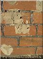
Buttered up
A benchmark in the wall of Redcatch Road, partly smothered by some new pointing. See http://www.bench-marks.org.uk/bm41480 for the entry in the Benchmark Database and Image] for a location view.
Image: © Neil Owen
Taken: 1 Feb 2012
0.06 miles
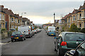
2
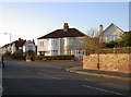
Junction of Redcatch Road and Woodbridge Road
Early evening sunshine bathes this suburban scene of Inter-war housing. See Image] for a benchmark that is almost obliterated.
Image: © Neil Owen
Taken: 1 Feb 2012
0.07 miles
3
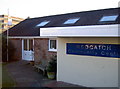
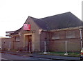
Redcatch Community Centre
This used to be a care centre for the elderly which was lined up for closure. It lay derelict for a number of years. However, the locals gathered to form an association to keep the building open as a community centre in 2002. Now it is a popular and busy asset, maintained by volunteers.
Image: © Neil Owen
Taken: 20 Jan 2017
0.07 miles
4
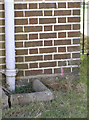
Benchmark on the old library
A cutmark, as described in the Benchmark Database: http://www.bench-marks.org.uk/bm41474 , on the corner of the library in Redcatch Road, Knowle. See Image] for a wide view of the disused building.
Image: © Neil Owen
Taken: 1 Feb 2012
0.08 miles
5
Late return?
The library in Redcatch Road was moved to the Broad Walk shopping centre just a short distance up the road, leaving this typically inter-war brick building to the elements. See Image] for a benchmark on its nearer corner.
Image: © Neil Owen
Taken: 1 Feb 2012
0.08 miles
6
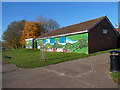
Colourful south side of Redcatch Community Centre, Knowle, Bristol
This is the Redcatch Park side of the community centre, located in Redcatch Road.
Image: © Jaggery
Taken: 11 Nov 2012
0.08 miles
7
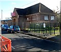
Former Knowle library for sale, Bristol
Viewed across Redcatch Road. Knowle library is now on the first floor
of the Broadwalk Shopping Centre, http://www.geograph.org.uk/photo/3225079 above a Subway restaurant.
Image: © Jaggery
Taken: 11 Nov 2012
0.08 miles
8
#248 and #250 Wells Road from Norton Road
#248 is a dentist practice; #250 is where I lived 1953-1960.
Image: © Roger Templeman
Taken: 28 Aug 2010
0.09 miles
9
2010 : West on Calcott Road, Knowle, Bristol
Image: © Maurice Pullin
Taken: 7 Nov 2010
0.09 miles
10
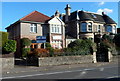
Cleve House School, Knowle, Bristol
The school is at 254 Wells Road, opposite Woodbridge Road.
The school has been on this site since 1948. Originally named Arcadia, Cleve House on the right was built in 1887 by Charles Beavis, a Victorian entrepreneur. It became known locally as the Lemonade Palace, because C.E.Beavis manufactured soft drinks in Jacob Street in the old market area of Bristol.
Image: © Jaggery
Taken: 11 Nov 2012
0.09 miles