IMAGES TAKEN NEAR TO
Marston Road, BRISTOL, BS4 2AJ
Introduction
This page details the photographs taken nearby to Marston Road, BS4 2AJ by members of the Geograph project.
The Geograph project started in 2005 with the aim of publishing, organising and preserving representative images for every square kilometre of Great Britain, Ireland and the Isle of Man.

There are currently over 7.5m images from over14,400 individuals and you can help contribute to the project by visiting https://www.geograph.org.uk
Image Map
Images are licensed for reuse under creativecommons.org/licenses/by-sa/2.0
Notes
- Clicking on the map will re-center to the selected point.
- The higher the marker number, the further away the image location is from the centre of the postcode.
Image Listing (83 Images Found)
Images are licensed for reuse under creativecommons.org/licenses/by-sa/2.0
Image
Details
Distance
1
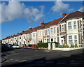
Maxse Road, Knowle, Bristol
A view NW from Greenmore Road.
According to one online source, this is the only Maxse Road in the UK.
Image: © Jaggery
Taken: 11 Nov 2012
0.03 miles
2
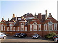
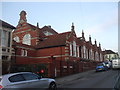
Old school
The Maxse Road school was built around 1900 in typical Bristol Board style. It is a fine example of many architectural details, ranging from Queen Anne to Roman, and was in use for around a century. However, the 'Baby Boomer' generation faded and the school was converted into residential flats. This shot is taken from the old playground area. See Image] for another view, and Image] for the memorial placed near the flats' entrance.
Image: © Neil Owen
Taken: 1 Feb 2012
0.04 miles
3

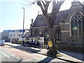
Redemption next to the Methodist church
The Redeemed Christian Church of God stands right next to the old church. Clearly there is quite a difference in their founding dates.
Image: © Neil Owen
Taken: 19 May 2022
0.04 miles
4
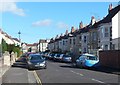
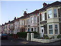
Hengrove Road, Knowle, Bristol
Viewed from the Redcatch Road end looking towards Wells Road.
Image: © Jaggery
Taken: 11 Nov 2012
0.05 miles
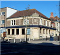
5
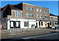
Lloyds TSB, Knowle, Bristol
Bank branch at 284 Wells Road. A NatWest branch is on the right. http://www.geograph.org.uk/photo/3225564
Image: © Jaggery
Taken: 11 Nov 2012
0.05 miles
6
Bus stop on Wells Road
Near Knowle Methodist Church
Image: © Eirian Evans
Taken: 11 Apr 2019
0.05 miles
8
Former school, Greenmore Rd, Bristol
For sale.
Image: © John Lord
Taken: 28 Jan 2012
0.05 miles
9
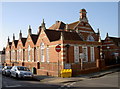
Maxse Road, old school
Image: © Neil Owen
Taken: 1 Feb 2012
0.06 miles
10
NatWest, Knowle, Bristol
Bank branch on the corner of Wells Road and Greenmore Road.
Image: © Jaggery
Taken: 11 Nov 2012
0.06 miles