IMAGES TAKEN NEAR TO
Exmouth Road, BRISTOL, BS4 1BD
Introduction
This page details the photographs taken nearby to Exmouth Road, BS4 1BD by members of the Geograph project.
The Geograph project started in 2005 with the aim of publishing, organising and preserving representative images for every square kilometre of Great Britain, Ireland and the Isle of Man.

There are currently over 7.5m images from over14,400 individuals and you can help contribute to the project by visiting https://www.geograph.org.uk
Image Map
Images are licensed for reuse under creativecommons.org/licenses/by-sa/2.0
Notes
- Clicking on the map will re-center to the selected point.
- The higher the marker number, the further away the image location is from the centre of the postcode.
Image Listing (8 Images Found)
Images are licensed for reuse under creativecommons.org/licenses/by-sa/2.0
Image
Details
Distance
1
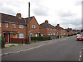
1930s council housing, Newquay road, Knowle West, Bristol
Typical 1930s brick council housing of this estate built in the 1930s.
Image: © Jez McNeill
Taken: 26 Aug 2011
0.10 miles
2
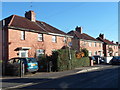
Salcombe Road, Knowle, Bristol
Houses at the NE end of Salcombe Road, viewed from the corner of Broad Walk.
Image: © Jaggery
Taken: 11 Nov 2012
0.18 miles
4
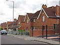
Typical 1930s housing Newquay Road, Knowle West, Bristol
Typical of the original garden estate housing of the 1930s Knowle West council estate.
Image: © Jez McNeill
Taken: 30 Aug 2011
0.22 miles
5
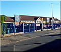
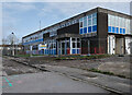
Knowle Park Primary School, Bristol
Viewed across Queenshill Road.
Image: © Jaggery
Taken: 11 Nov 2012
0.23 miles
6
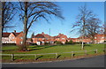
Green at the western end of Broad Walk, Knowle, Bristol
The green is about 70 metres long and 35 metres wide.
Image: © Jaggery
Taken: 11 Nov 2012
0.24 miles
7
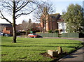
Small green in front of the church
Along Daventry Road is St Barnabas church, set back from the main road in St Barnabas Close appropriately enough. See Image] for a better view and a little more history.
Image: © Neil Owen
Taken: 1 Feb 2012
0.25 miles
8
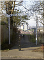
Northern Slopes
Behind St Barnabas church is the steep hill known locally as The Bombey' but now officially as The Northern Slopes. A WWII bomb crater can still be made out although the softening of time and the advance of the undergrowth makes this less obvious. See Image] for a fine view of South Bristol.
Image: © Neil Owen
Taken: 1 Feb 2012
0.25 miles