IMAGES TAKEN NEAR TO
Bourton Mead, Long Ashton Road, BRISTOL, BS41 9LZ
Introduction
This page details the photographs taken nearby to Bourton Mead, Long Ashton Road, BS41 9LZ by members of the Geograph project.
The Geograph project started in 2005 with the aim of publishing, organising and preserving representative images for every square kilometre of Great Britain, Ireland and the Isle of Man.

There are currently over 7.5m images from over14,400 individuals and you can help contribute to the project by visiting https://www.geograph.org.uk
Image Map
Images are licensed for reuse under creativecommons.org/licenses/by-sa/2.0
Notes
- Clicking on the map will re-center to the selected point.
- The higher the marker number, the further away the image location is from the centre of the postcode.
Image Listing (30 Images Found)
Images are licensed for reuse under creativecommons.org/licenses/by-sa/2.0
Image
Details
Distance
1
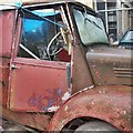
Old Red Truck
An old red truck outside Cox's, Long Ashton.
Image: © Stephen Elwyn RODDICK
Taken: 19 Jul 2012
0.05 miles
3
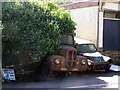
Long Stay parking
A morris minor van to the right of an unidentified truck
Image: © Steve Coffin
Taken: 22 Aug 2009
0.05 miles
5

New build detached houses
Long Ashton
Image: © Anthony O'Neil
Taken: 15 Jun 2020
0.10 miles
6
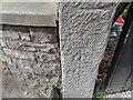
Ordnance Survey Cut Mark
This OS cut mark can be found on a gatepost of No75 Long Ashton Road. It marks a point 43.120m above mean sea level.
Image: © Adrian Dust
Taken: 23 Aug 2022
0.10 miles
8
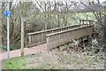
Footbridge over Ashton Brook
Path towards Yanley
Image: © Anthony O'Neil
Taken: 6 Mar 2021
0.11 miles
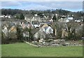
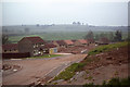
9
Long Ashton - Farm buildings converted to business units
Image: © FollowMeChaps
Taken: 4 Jan 2006
0.11 miles
10
Building progress at Ashton Theynes Estate, Long Ashton
Image: © Colin Park
Taken: 3 Jun 1979
0.13 miles