IMAGES TAKEN NEAR TO
Long Ashton Road, BRISTOL, BS41 9JQ
Introduction
This page details the photographs taken nearby to Long Ashton Road, BS41 9JQ by members of the Geograph project.
The Geograph project started in 2005 with the aim of publishing, organising and preserving representative images for every square kilometre of Great Britain, Ireland and the Isle of Man.

There are currently over 7.5m images from over14,400 individuals and you can help contribute to the project by visiting https://www.geograph.org.uk
Image Map (Loading...)


Getting Data...Please wait
Leaflet Map data © OpenStreetMap
Images are licensed for reuse under creativecommons.org/licenses/by-sa/2.0
Notes
- Clicking on the map will re-center to the selected point.
- The higher the marker number, the further away the image location is from the centre of the postcode.
Image Listing (75 Images Found)
Images are licensed for reuse under creativecommons.org/licenses/by-sa/2.0
Image
Details
Distance
1
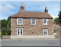
Around Long Ashton (7)
'Sunnymead': from circa 1600
Image: © Anthony O'Neil
Taken: 15 Jun 2020
0.04 miles
2
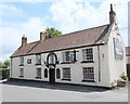
Around Long Ashton (6)
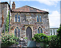
The Angel pub
Image: © Anthony O'Neil
Taken: 15 Jun 2020
0.05 miles

5
An angel in Long Ashton
Doubtless many a prayer for refreshment has been answered here. The inn dates back to 1495 and was a gift from a local landlord, Sir John Choke. In return for the inn and a quantity of land donated to the parish, the villagers prayed for the deliverance of him and his family. Associated with the inn were the Church Houses, which held meetings and fund-raising activities. (These were sold off and new Church Houses founded in 1907 at Westleaze.)
The Angel Inn flourished when the roads were improved during the turnpike era and became an important coaching post.
Image: © Neil Owen
Taken: 2 Nov 2018
0.05 miles
6
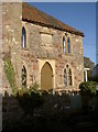
The old school on Church Lane
Long Ashton has a long history regarding education of its villagers. Many charitable organisations helped the children, but in 1818 a National Society grant of £75 allowed the construction of this small school house in Church Lane. It featured a master's house and two schoolrooms. A new school was built in 1861, whereupon the old buildings were sold off to private hands.
See Image] for a look at the date stone.
Image: © Neil Owen
Taken: 2 Nov 2018
0.06 miles
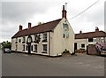
7
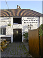
Good coach house and stable
A sign from the earlier history of The Angel inn at Long Ashton.
Image: © Neil Owen
Taken: 2 Nov 2018
0.06 miles
8
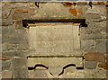
School date stone
The date stone of the old school - see Image] for a wider view and a history.
Image: © Neil Owen
Taken: 2 Nov 2018
0.06 miles
9
Around Long Ashton (8)
Former School residence: pre-1861
Image: © Anthony O'Neil
Taken: 15 Jun 2020
0.06 miles
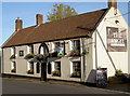
10
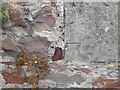
Ordnance Survey Cut Mark
This OS cut mark can be found on the roadside building at The Angel PH, Church Lane. It marks a point 31.330m above mean sea level.
Image: © Adrian Dust
Taken: 24 Aug 2022
0.06 miles