IMAGES TAKEN NEAR TO
Folleigh Lane, BRISTOL, BS41 9HZ
Introduction
This page details the photographs taken nearby to Folleigh Lane, BS41 9HZ by members of the Geograph project.
The Geograph project started in 2005 with the aim of publishing, organising and preserving representative images for every square kilometre of Great Britain, Ireland and the Isle of Man.

There are currently over 7.5m images from over14,400 individuals and you can help contribute to the project by visiting https://www.geograph.org.uk
Image Map (Loading...)


Getting Data...Please wait
Leaflet Map data © OpenStreetMap
Images are licensed for reuse under creativecommons.org/licenses/by-sa/2.0
Notes
- Clicking on the map will re-center to the selected point.
- The higher the marker number, the further away the image location is from the centre of the postcode.
Image Listing (39 Images Found)
Images are licensed for reuse under creativecommons.org/licenses/by-sa/2.0
Image
Details
Distance
1

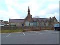
Northleaze School
The Smyth family owned plenty of land in this area, and kindly donated this patch for the construction of a parochial school in 1860. Public donations provided the £2,200 required to start work. The official opening was 21st January, 1862 and welcomed all local children, not just Church of England ones.
A new Northleaze School opened not far away in Brook Close.
Image: © Neil Owen
Taken: 2 Nov 2018
0.06 miles
3
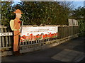
Long Ashton will remember
A striking sign to mark the centenary of the end of WWI.
Image: © Neil Owen
Taken: 2 Nov 2018
0.07 miles
4
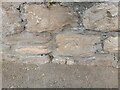
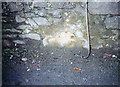
Ordnance Survey Cut Mark
This OS cut mark can be found on No107 Long Ashton Road. It marks a point 40.295m above mean sea level.
Image: © Adrian Dust
Taken: 23 Aug 2022
0.07 miles
5
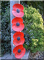
Poppies at the top of Yanley Lane
Long Ashton's tribute to the fallen of WWI features many of these large poppies on roadside poles. Each has a hand-written description of a man and his regiment. The writing seems to be that of school pupils.
Image: © Neil Owen
Taken: 2 Nov 2018
0.07 miles
6
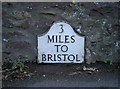
Old Milestone by Long Ashton Road, Long Ashton parish
Metal plate attached to stone post by the UC road (was A370), in parish of LONG ASHTON (NORTH SOMERSET District), Long Ashton Road, in field wall opposite No. 79, set into wall of public car park, and fixed to original stone, on South side of road. Bristol iron plate, erected by the Bristol turnpike trust in the 19th century.
Inscription once read:-
3
MILES
TO
BRISTOL
Grade II listed.
List Entry Number: 1129036 https://historicengland.org.uk/listing/the-list/list-entry/1129036
Milestone Society National ID: SO_BRWS03.
Image: © JR Dowding
Taken: 19 May 2008
0.08 miles
8
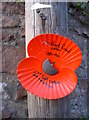
A specific poppy memorial
This large poppy appears to commemorate an individual soldier of the Great War. Several telegraph poles along the main road have such dedications.
The name appears to be Gilbert Russel Walker, 1881-1916, 21st Field Company, South Midlands Royal. The Division left Salisbury Plain training camps for the attack on Fromelles, near the Somme - which claimed many lives in a terrible encounter, 19th July, 1916.
The number 172 refers to the actual telegraph pole.
Image: © Neil Owen
Taken: 2 Nov 2018
0.09 miles
9
A milestone without a stone
Unusually, this mile marker has the (all too often stolen) metal plate, but not the stone.
Image: © Neil Owen
Taken: 2 Nov 2018
0.09 miles
10
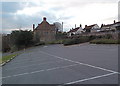
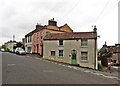
School car park in Long Ashton
On a hillside near the main road and unusually steep - especially at the entrance.
Image: © Anthony O'Neil
Taken: 21 Jan 2011
0.09 miles