IMAGES TAKEN NEAR TO
Chestnut Road, BRISTOL, BS41 9HR
Introduction
This page details the photographs taken nearby to Chestnut Road, BS41 9HR by members of the Geograph project.
The Geograph project started in 2005 with the aim of publishing, organising and preserving representative images for every square kilometre of Great Britain, Ireland and the Isle of Man.

There are currently over 7.5m images from over14,400 individuals and you can help contribute to the project by visiting https://www.geograph.org.uk
Image Map
Images are licensed for reuse under creativecommons.org/licenses/by-sa/2.0
Notes
- Clicking on the map will re-center to the selected point.
- The higher the marker number, the further away the image location is from the centre of the postcode.
Image Listing (35 Images Found)
Images are licensed for reuse under creativecommons.org/licenses/by-sa/2.0
Image
Details
Distance
1
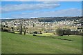
Long Ashton Village
From Hanging Hill
Image: © Anthony O'Neil
Taken: 6 Mar 2021
0.04 miles
2
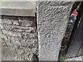
Ordnance Survey Cut Mark
This OS cut mark can be found on a gatepost of No75 Long Ashton Road. It marks a point 43.120m above mean sea level.
Image: © Adrian Dust
Taken: 23 Aug 2022
0.07 miles
4
Long Stay parking
A morris minor van to the right of an unidentified truck
Image: © Steve Coffin
Taken: 22 Aug 2009
0.08 miles
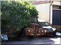
5

Old Red Truck
An old red truck outside Cox's, Long Ashton.
Image: © Stephen Elwyn RODDICK
Taken: 19 Jul 2012
0.09 miles
6
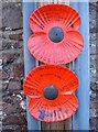
The Gunstons' memorial
Long Ashton has a prominent way to commemorate the loss of men in WWI as the centenary approaches. Several telegraph poles have sprouted these large poppies; they all have hand-written descriptions of men who were lost during the conflict. These two are in memory of two men named Gunston - one of whom appears to have lived in the village.
Image: © Neil Owen
Taken: 2 Nov 2018
0.10 miles
7
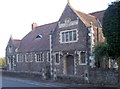
Long Ashton Church House
The inscription reads:
'For this house I've done my best, God I trust will do the rest.'
See Image] for a wider look.
Image: © Neil Owen
Taken: 2 Nov 2018
0.12 miles
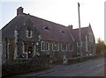
8
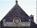
A gift from Lady Smyth
The old Church House near the Angel Inn was becoming a little crowded so the local landowners, the Smyth family, paid to have this new building in 1907. See Image] for a look at the noble legend above the main entrance.
Image: © Neil Owen
Taken: 2 Nov 2018
0.12 miles
9
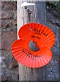
A specific poppy memorial
This large poppy appears to commemorate an individual soldier of the Great War. Several telegraph poles along the main road have such dedications.
The name appears to be Gilbert Russel Walker, 1881-1916, 21st Field Company, South Midlands Royal. The Division left Salisbury Plain training camps for the attack on Fromelles, near the Somme - which claimed many lives in a terrible encounter, 19th July, 1916.
The number 172 refers to the actual telegraph pole.
Image: © Neil Owen
Taken: 2 Nov 2018
0.12 miles
10
Church House on Long Ashton Road
A large hall, with a good sized car park too.
Image: © Neil Owen
Taken: 2 Nov 2018
0.13 miles