IMAGES TAKEN NEAR TO
Bramley Copse, BRISTOL, BS41 9FG
Introduction
This page details the photographs taken nearby to Bramley Copse, BS41 9FG by members of the Geograph project.
The Geograph project started in 2005 with the aim of publishing, organising and preserving representative images for every square kilometre of Great Britain, Ireland and the Isle of Man.

There are currently over 7.5m images from over14,400 individuals and you can help contribute to the project by visiting https://www.geograph.org.uk
Image Map (Loading...)


Getting Data...Please wait
Leaflet Map data © OpenStreetMap
Images are licensed for reuse under creativecommons.org/licenses/by-sa/2.0
Notes
- Clicking on the map will re-center to the selected point.
- The higher the marker number, the further away the image location is from the centre of the postcode.
Image Listing (46 Images Found)
Images are licensed for reuse under creativecommons.org/licenses/by-sa/2.0
Image
Details
Distance
1
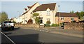
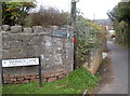
Junction, Weston Road, Long Ashton
Kings Croft turns to the right off the former main road.
Image: © Derek Harper
Taken: 3 May 2016
0.05 miles
2
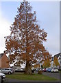
The Dawn Redwood
This magnificent specimen is a Dawn Redwood (Metasequoia glyptostroboides) and was planted here after WWII when the area was very much part of the Long Ashton Research Station. The genus carries a little history in that it was 'discovered' in China and was declared to be that of a living species that was identical to fossils found from over 100 million years ago!
Image: © Neil Owen
Taken: 15 Nov 2018
0.05 miles
3

Weston Road, Long Ashton
A little past the junction shown in Image The house with two canted bays, the former Fenswood Farmhouse, is listed and described at https://www.historicengland.org.uk/listing/the-list/list-entry/1129038 ; the house beyond is also listed https://www.historicengland.org.uk/listing/the-list/list-entry/1129039 .
Image: © Derek Harper
Taken: 3 May 2016
0.06 miles
4
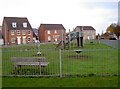
Chancellor's Park play area
As part of the redevelopment of the old Long Ashton Research Station, this children's play area was installed; it is surrounded by housing.
Image: © Neil Owen
Taken: 15 Nov 2018
0.08 miles
5
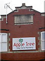
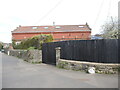
Old and new apples
The old part of the former Long Ashton Research Station is one of a few that have been retained after the lands were redeveloped as modern housing. The old organisation was formed in 1903 as The National Fruit and Cider Institute and occupied a site on the sloping land to the north. In 1912 it became the Agricultural and Horticultural Research Station and diversified into many aspects of growing and cultivating fruit crops, especially apples. One well-known benefit was the use of blackcurrants in a drink high in vitamin C - as the government in WWII pushed to feed the children in times of rationing. Hence Ribena became a household favourite.
The station was closely associated with university work but the whole lot was closed in 2003. A nursery now occupies the building with an appropriate name - seeing as cider was a big part of the history.
Image: © Neil Owen
Taken: 15 Nov 2018
0.08 miles
6
Warren Lane
And a number of footpaths over the woodlands above Long Ashton.
Image: © Neil Owen
Taken: 15 Nov 2018
0.08 miles
7
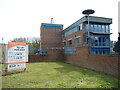
Estune is open for business
The business park is built on the lands of the old cider research institute. Some units are occupied, others on offer.
Image: © Neil Owen
Taken: 10 Apr 2022
0.08 miles
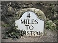
8

Old Milestone by road (was A370), Weston Road, West end of Long Ashton, near junction with Wild Country Lane
The Milestone is located in tarmac pavement in front of stone wall on the East of the road. Parish of Long Ashton (North Somerset District). Metal plate attached to stone post, Bristol iron plate design, erected by the Bristol Turnpike Trust in the 19th Century, plate lost since 1967 survey and 1970s pic; rough surface and sunken; new plate by persons unknown 2012. A newer photograph can be found here: https://www.geograph.org.uk/photo/4864560
Inscription reads:- 4 / MILES / TO / BRISTOL
Grade II listed. List Entry Number: 1129040 https://historicengland.org.uk/listing/the-list/list-entry/1129040
Milestone Society National ID: SO_BRWS04
Image: © Janet Dowding
Taken: 18 Jan 2003
0.09 miles
9
Long Ashton milestone
The roadside marker close to the west end of Long Ashton, near the former Cider Research station. See Image] for a closer look at the former.
Image: © Neil Owen
Taken: 10 Apr 2022
0.09 miles
10
Milestone at the end of Long Ashton
At the junction of the Weston Road and Wildcountry Lane is a milestone with a more modern plate, if a little flaky these days. See Image] for a wider view.
Image: © Neil Owen
Taken: 10 Apr 2022
0.09 miles