IMAGES TAKEN NEAR TO
Fenns Lane, BRISTOL, BS41 9FD
Introduction
This page details the photographs taken nearby to Fenns Lane, BS41 9FD by members of the Geograph project.
The Geograph project started in 2005 with the aim of publishing, organising and preserving representative images for every square kilometre of Great Britain, Ireland and the Isle of Man.

There are currently over 7.5m images from over14,400 individuals and you can help contribute to the project by visiting https://www.geograph.org.uk
Image Map (Loading...)


Getting Data...Please wait
Leaflet Map data © OpenStreetMap
Images are licensed for reuse under creativecommons.org/licenses/by-sa/2.0
Notes
- Clicking on the map will re-center to the selected point.
- The higher the marker number, the further away the image location is from the centre of the postcode.
Image Listing (27 Images Found)
Images are licensed for reuse under creativecommons.org/licenses/by-sa/2.0
Image
Details
Distance
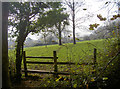
1
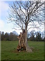
A lost heart near Fenn's Wood
A tree has apparently survived a severe loss of heart, although not without some effort.
Image: © Neil Owen
Taken: 15 Nov 2018
0.06 miles
2
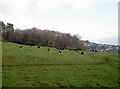
An old farmstead above Long Ashton?
A few faint earthworks have been determined on the slopes above the village. A short distance away at Gatcombe Farm a Roman settlement was discovered, and there have been a few Roman coin finds locally. Other earthworks also point to a later occupation of a mediaeval farmstead.
Image: © Neil Owen
Taken: 15 Nov 2018
0.07 miles
3
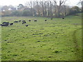
Earth outlines above Long Ashton
The area above the village around Fenn's Wood, The Brake and Keed's Wood is steeply sloping pasture, but there remains a few odd lumps and bumps in the landscape. It is believed to be the marks of a Roman-British settlement.
Image: © Neil Owen
Taken: 15 Nov 2018
0.07 miles
4
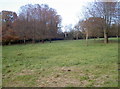
Between the woods
There appears to have been a settlement in this area above Long Ashton, but the outlines are difficult to see. Some linear features were discerned and thought to be Romano-British in origin. Later field systems are nearby.
Image: © Neil Owen
Taken: 15 Nov 2018
0.11 miles
5
The edge of Keed's Wood
The footpath skirts in and out of the trees.
Image: © Neil Owen
Taken: 15 Nov 2018
0.12 miles
6
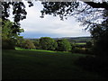
View towards Hartcliffe & Dundry Hill from George's Hill Plantation, Failand
Image: © Colin Park
Taken: 20 Oct 2013
0.15 miles
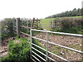
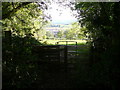
7
The paths above Warren Lane
Some old school angle iron to provide a stile, along with the more common and modern kissing gates.
Image: © Neil Owen
Taken: 15 Nov 2018
0.16 miles
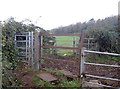
8
Double gates on Warren Lane
A footpath crosses the hillside above Long Ashton and meets Warren Lane at right angles. The lane is somewhat newer than the path, having been extended from the village down the hillside.
Image: © Neil Owen
Taken: 10 Apr 2022
0.16 miles
9

Snow scene, Old plough in field above Long Ashton
The old plough has long since gone.
Image: © Colin Park
Taken: 12 Dec 1981
0.17 miles
10
Kissing gate at edge of George's Hill Plantation.
Image: © Colin Park
Taken: 24 Oct 2010
0.18 miles