IMAGES TAKEN NEAR TO
Heath Ridge, BRISTOL, BS41 9EW
Introduction
This page details the photographs taken nearby to Heath Ridge, BS41 9EW by members of the Geograph project.
The Geograph project started in 2005 with the aim of publishing, organising and preserving representative images for every square kilometre of Great Britain, Ireland and the Isle of Man.

There are currently over 7.5m images from over14,400 individuals and you can help contribute to the project by visiting https://www.geograph.org.uk
Image Map (Loading...)


Getting Data...Please wait
Leaflet Map data © OpenStreetMap
Images are licensed for reuse under creativecommons.org/licenses/by-sa/2.0
Notes
- Clicking on the map will re-center to the selected point.
- The higher the marker number, the further away the image location is from the centre of the postcode.
Image Listing (19 Images Found)
Images are licensed for reuse under creativecommons.org/licenses/by-sa/2.0
Image
Details
Distance
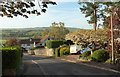
1
Heath Park, Long Ashton
From across Highlands Road.
Image: © Derek Harper
Taken: 3 May 2016
0.05 miles
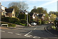
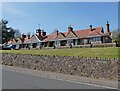
2
Highlands Road, Long Ashton
A reverse view of Image], looking up the hill from the junction with Kempes Close; Estune Walk is on the left.
Image: © Derek Harper
Taken: 3 May 2016
0.06 miles
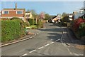
3
Highlands Road, Long Ashton
Looking down the steep residential road past junctions with Estune Walk and Kempes Close.
Image: © Derek Harper
Taken: 3 May 2016
0.06 miles
4

Footpath, Long Ashton
Footpath LA12 24/40 leaves Short Lane to climb the side of Ashton Hill.
Image: © Derek Harper
Taken: 3 May 2016
0.09 miles
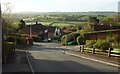
5
Highlands Road, Long Ashton
Dropping to the T junction with Ridgeway Road; the Ashton Brook valley is beyond.
Image: © Derek Harper
Taken: 3 May 2016
0.10 miles
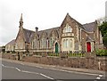
9
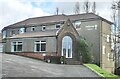
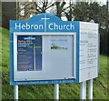
Hebron Church
Providence Lane, Long Ashton
Image: © Anthony O'Neil
Taken: 22 Feb 2021
0.18 miles