IMAGES TAKEN NEAR TO
Keedwell Hill, BRISTOL, BS41 9DP
Introduction
This page details the photographs taken nearby to Keedwell Hill, BS41 9DP by members of the Geograph project.
The Geograph project started in 2005 with the aim of publishing, organising and preserving representative images for every square kilometre of Great Britain, Ireland and the Isle of Man.

There are currently over 7.5m images from over14,400 individuals and you can help contribute to the project by visiting https://www.geograph.org.uk
Image Map (Loading...)


Getting Data...Please wait
Leaflet Map data © OpenStreetMap
Images are licensed for reuse under creativecommons.org/licenses/by-sa/2.0
Notes
- Clicking on the map will re-center to the selected point.
- The higher the marker number, the further away the image location is from the centre of the postcode.
Image Listing (51 Images Found)
Images are licensed for reuse under creativecommons.org/licenses/by-sa/2.0
Image
Details
Distance
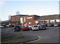
1
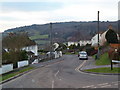
Junction of Keedwell Hill and Providence Lane, Long Ashton
Image: © Anthony O'Neil
Taken: 21 Jan 2011
0.06 miles
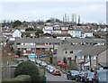
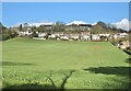
2
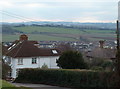
View over Long Ashton from Providence Lane
Image: © Anthony O'Neil
Taken: 21 Jan 2011
0.08 miles
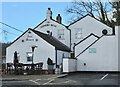
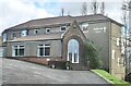
5
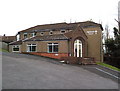
Long Ashton community centre
The village once had an association, formed in 1944 and set out to raise enough funds to build a new hall. The old one on what is now Lovelinch Gardens was sold, along with the land, and new fields in Keedwell Road made available. The objective was to provide a “first class Village Hall and enlargement of the Recreation Ground” and by 1957 the association had secured about £10,000 for the job. By June, 1959, the foundation stone was laid and the hall officially opened on 14th November, 1959. Subsequent additions and enlargements have increased the scope of the community asset.
Image: © Neil Owen
Taken: 15 Nov 2018
0.11 miles
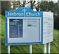
6
Hebron Church
Providence Lane, Long Ashton
Image: © Anthony O'Neil
Taken: 22 Feb 2021
0.11 miles
8
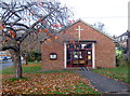
Keedwell Church
Located high up along Long Ashton's hillside, the Church of the Ascension occupies part of the newer estates, built post-war. It originally started out as Church of England, but later became the Hebron and is now also known as Keedwell church.
Image: © Neil Owen
Taken: 15 Nov 2018
0.12 miles
10
Houses at Providence Lane
From Keed's Lane, Long Ashton
Image: © Anthony O'Neil
Taken: 22 Feb 2021
0.13 miles