IMAGES TAKEN NEAR TO
Lampton Road, BRISTOL, BS41 9AL
Introduction
This page details the photographs taken nearby to Lampton Road, BS41 9AL by members of the Geograph project.
The Geograph project started in 2005 with the aim of publishing, organising and preserving representative images for every square kilometre of Great Britain, Ireland and the Isle of Man.

There are currently over 7.5m images from over14,400 individuals and you can help contribute to the project by visiting https://www.geograph.org.uk
Image Map (Loading...)


Getting Data...Please wait
Leaflet Map data © OpenStreetMap
Images are licensed for reuse under creativecommons.org/licenses/by-sa/2.0
Notes
- Clicking on the map will re-center to the selected point.
- The higher the marker number, the further away the image location is from the centre of the postcode.
Image Listing (44 Images Found)
Images are licensed for reuse under creativecommons.org/licenses/by-sa/2.0
Image
Details
Distance
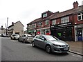
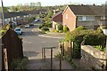
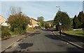
1
Lampton Road, Long Ashton
With the junction with Elmhurst Gardens on the left.
Image: © Derek Harper
Taken: 3 May 2016
0.03 miles
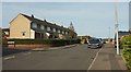
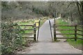
2
View towards Long Ashton
As seen from the Monarch's Way long distance footpath, south of Long Ashton
Image: © Chris Heaton
Taken: 9 Feb 2016
0.07 miles
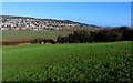
3
Long Ashton
A view from footpath LA12 24/40 on Ashton Hill over the roofs of the village and the Ashton Brook valley. Behind the row of poplars is Birdwell Primary School.
Image: © Derek Harper
Taken: 3 May 2016
0.07 miles
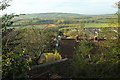
4
Yeomeads, Long Ashton
Seen from Yeo Lane, the path descending from Weston Road.
Image: © Derek Harper
Taken: 3 May 2016
0.07 miles
5
Entrance to Dawson Walk (1982)
Long Ashton
Image: © Anthony O'Neil
Taken: 6 Mar 2021
0.09 miles
6
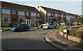
Fenshurst Gardens, Long Ashton
From across the junction with Elmhurst Gardens.
Image: © Derek Harper
Taken: 3 May 2016
0.10 miles
7
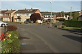
Monarch's Way through Long Ashton
Not the most obvious route for an LDP, although it is in fact following the line of public footpath LA12 7/10 as it progresses along Lampton Road in the foreground and then turns right up Lovelinch Gardens.
Image: © Derek Harper
Taken: 3 May 2016
0.10 miles
8
Yeo Lane, Long Ashton
Climbing the valley side between Yeomeads and the Weston Road at the Bird In Hand pub.
Image: © Derek Harper
Taken: 3 May 2016
0.11 miles
9
Fenshurst Gardens, Long Ashton
Nearly a reverse view of Image], again with the junction with Paulman Gardens.
Image: © Derek Harper
Taken: 3 May 2016
0.11 miles