IMAGES TAKEN NEAR TO
East Dundry Lane, BRISTOL, BS41 8NJ
Introduction
This page details the photographs taken nearby to East Dundry Lane, BS41 8NJ by members of the Geograph project.
The Geograph project started in 2005 with the aim of publishing, organising and preserving representative images for every square kilometre of Great Britain, Ireland and the Isle of Man.

There are currently over 7.5m images from over14,400 individuals and you can help contribute to the project by visiting https://www.geograph.org.uk
Image Map (Loading...)


Getting Data...Please wait
Leaflet Map data © OpenStreetMap
Images are licensed for reuse under creativecommons.org/licenses/by-sa/2.0
Notes
- Clicking on the map will re-center to the selected point.
- The higher the marker number, the further away the image location is from the centre of the postcode.
Image Listing (43 Images Found)
Images are licensed for reuse under creativecommons.org/licenses/by-sa/2.0
Image
Details
Distance
1
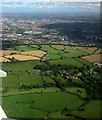
East Dundry from the air
An aerial photo looking towards the southern suburbs of Bristol, with part of the village of East Dundry and Dundry Hill. The mast shown at http://www.geograph.org.uk/search.php?i=65863676 can be seen in the centre just beyond North Hill Farm.
Image: © Derek Harper
Taken: 8 Sep 2016
0.01 miles
2

Maiden Head valley
Afternoon sunlight shows off the contours of the terrain nicely. A stream works its way down, fed by several issues.
Image: © Neil Owen
Taken: 16 Mar 2021
0.03 miles
3
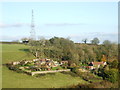
Farms and cottages near East Dundry
Nestling in the slopes of the Dundry ridge and comforted by tree cover. The high land is also home to several masts, one of which lives just up the hill.
Image: © Neil Owen
Taken: 18 Nov 2019
0.04 miles
5
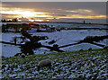
A cold end to the day, a cold night ahead
The snow of the previous evening is still much in evidence; the day's warmth has yet to find the north-facing slopes and a frosty night is forecast. Thick woollens are the order of the day.
Image: © Neil Owen
Taken: 28 Dec 2017
0.06 miles
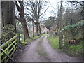
6
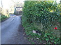
East Dundry end
A badger has fallen victim here on the lane. See Image] for a closer look at the deceased animal.
Image: © Neil Owen
Taken: 18 Nov 2019
0.07 miles
7
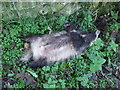
Badger belly up
Alas, poor Brock! This unfortunate animal seems to have met an automotive end on East Dundry Lane. See Image] for a wider look at the grave site.
Image: © Neil Owen
Taken: 18 Nov 2019
0.07 miles
8
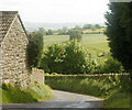
2009 : East Dundry Lane at East Dundry
Looking south, the remains of ancient strip farming can be seen on the hillside. The distant Mendips are just visible through the remains of a passing shower (nearly caught me, that one).
Image: © Maurice Pullin
Taken: 26 May 2009
0.07 miles
9
North Hill Farm in December
Light snowfall adds to the scene.
Image: © Neil Owen
Taken: 28 Dec 2017
0.08 miles
10
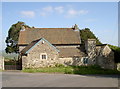
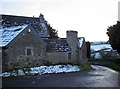
North Hill Farm
Part of the number of farm buildings at the higher point of East Dundry Lane.
Image: © Neil Owen
Taken: 9 May 2017
0.08 miles