IMAGES TAKEN NEAR TO
Wells Road, BRISTOL, BS41 8NG
Introduction
This page details the photographs taken nearby to Wells Road, BS41 8NG by members of the Geograph project.
The Geograph project started in 2005 with the aim of publishing, organising and preserving representative images for every square kilometre of Great Britain, Ireland and the Isle of Man.

There are currently over 7.5m images from over14,400 individuals and you can help contribute to the project by visiting https://www.geograph.org.uk
Image Map (Loading...)


Getting Data...Please wait
Leaflet Map data © OpenStreetMap
Images are licensed for reuse under creativecommons.org/licenses/by-sa/2.0
Notes
- Clicking on the map will re-center to the selected point.
- The higher the marker number, the further away the image location is from the centre of the postcode.
Image Listing (12 Images Found)
Images are licensed for reuse under creativecommons.org/licenses/by-sa/2.0
Image
Details
Distance
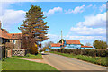
1
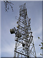
Dundry East mast
One of the seven masts on Dundry ridge, this triangular structure delivers DAB radio to the area.
Image: © Neil Owen
Taken: 5 May 2016
0.07 miles
2
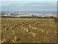
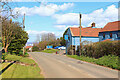
Rows of crop, rows of buildings
The lofty position of Dundry is a highly desirable location, what with its views over the city of Bristol. It also has some rich agricultural lands, and the crops are now just low stalks.
Image: © Neil Owen
Taken: 18 Nov 2019
0.13 miles
3
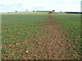
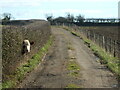
Hard to grow on the path
Crops planted recently are starting to emerge, although the footpath makes it more difficult.
Image: © Neil Owen
Taken: 16 Mar 2021
0.14 miles
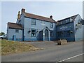
5
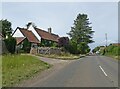
Carpenters Tavern
Public House near Dundry.
Image: © Wayland Smith
Taken: 5 Apr 2021
0.17 miles
6
Carpenters Tavern
Public House near Dundry.
Image: © Wayland Smith
Taken: 5 Apr 2021
0.17 miles
8
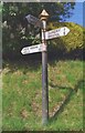
Old Direction Sign - Signpost by Wells Road, Dundry Parish
Pyramid finial - 3 arms; Somerset SCC pyramid by the UC road, in parish of Dundry (North Somerset District), Wells Road junction with Upton Lane, Maiden Head.
Surveyed
Milestone Society National ID: SO_ST5666
Image: © Milestone Society
Taken: Unknown
0.18 miles
9
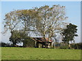
Disused Barn
On top of Dundry hill stands this derelict farm building. Currently being used by the local sheep population for shade and other sheep business.
Image: © MD
Taken: 12 Oct 2008
0.18 miles
10
Can't reach far enough
A large head pops through the hedge. There appears to be a desire to get into the next field, even though it has been ploughed and there is no grass on it. Thanfully the hedge is quite thick, with a line of wire fencing, so the cow and its friends are kept in the meadow. For now, at least.
Image: © Neil Owen
Taken: 16 Mar 2021
0.19 miles