IMAGES TAKEN NEAR TO
Wells Road, BRISTOL, BS41 8NE
Introduction
This page details the photographs taken nearby to Wells Road, BS41 8NE by members of the Geograph project.
The Geograph project started in 2005 with the aim of publishing, organising and preserving representative images for every square kilometre of Great Britain, Ireland and the Isle of Man.

There are currently over 7.5m images from over14,400 individuals and you can help contribute to the project by visiting https://www.geograph.org.uk
Image Map (Loading...)


Getting Data...Please wait
Leaflet Map data © OpenStreetMap
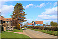
Images are licensed for reuse under creativecommons.org/licenses/by-sa/2.0
Notes
- Clicking on the map will re-center to the selected point.
- The higher the marker number, the further away the image location is from the centre of the postcode.
Image Listing (30 Images Found)
Images are licensed for reuse under creativecommons.org/licenses/by-sa/2.0
Image
Details
Distance
2
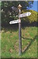
Old Direction Sign - Signpost by Wells Road, Dundry Parish
Pyramid finial - 3 arms; Somerset SCC pyramid by the UC road, in parish of Dundry (North Somerset District), Wells Road junction with Upton Lane, Maiden Head.
Surveyed
Milestone Society National ID: SO_ST5666
Image: © Milestone Society
Taken: Unknown
0.02 miles
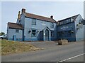
3
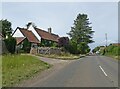
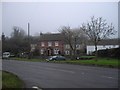
Carpenters Tavern
Public House near Dundry.
Image: © Wayland Smith
Taken: 5 Apr 2021
0.03 miles
4
Carpenters Tavern
Public House near Dundry.
Image: © Wayland Smith
Taken: 5 Apr 2021
0.03 miles
6

The fields are alive with the sound of sheep
Lambing has gone well this year for these creatures: mothers and offspring are bleating merrily in the afternoon sunshine.
Image: © Neil Owen
Taken: 16 Mar 2021
0.12 miles
7
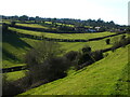
Sheep grazing near Maiden Head
Gently sloping fields at the top of the valley provide some grazing.
Image: © Neil Owen
Taken: 16 Mar 2021
0.14 miles
8
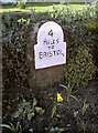
All downhill from here!
A curious milestone at the top of Dundry ridge, close to the crossroads of the West and East Dundry Lanes.
Image: © Neil Owen
Taken: 14 Mar 2013
0.15 miles
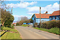
9
Dwellings at the junction of West Dundry Lane and Broadoak Hill
Image: © John Lord
Taken: 21 Dec 2011
0.15 miles