IMAGES TAKEN NEAR TO
Winford Terrace, BRISTOL, BS41 8JR
Introduction
This page details the photographs taken nearby to Winford Terrace, BS41 8JR by members of the Geograph project.
The Geograph project started in 2005 with the aim of publishing, organising and preserving representative images for every square kilometre of Great Britain, Ireland and the Isle of Man.

There are currently over 7.5m images from over14,400 individuals and you can help contribute to the project by visiting https://www.geograph.org.uk
Image Map
Images are licensed for reuse under creativecommons.org/licenses/by-sa/2.0
Notes
- Clicking on the map will re-center to the selected point.
- The higher the marker number, the further away the image location is from the centre of the postcode.
Image Listing (18 Images Found)
Images are licensed for reuse under creativecommons.org/licenses/by-sa/2.0
Image
Details
Distance
2

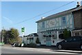
'La Campagna' restaurant and bar
Formerly, the Winford Arms
Image: © Roger Cornfoot
Taken: 19 Apr 2021
0.01 miles
3
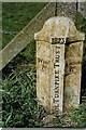
Lost Boundary Marker on the A38 Bridgwater Road north of Barrow Common
Turnpike Parish Boundary Marker north of Barrow Common on the north side of the A38 Bridgwater Road opposite the former Winford Arms PH, now La Campagna. On the former boundary of Winford and Log Ashton parishes, now Dundry and Long Ashton. In raised lettering WINFD / PH on the left face, ASHTON / PH on the right face with BRISTOL TURNPIKE TRUST vertically between them on the front face with 1823 horizontally above. Lost some time between 26 March 1989 and 11 May 2021.
Milestone Society National ID: SO_DULASH01pb
Image: © Milestone Society
Taken: 26 Mar 1989
0.03 miles
5
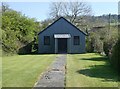
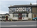
Chapel on Bridgewater Road
Appears to be disused and access locked.
Image: © Roger Cornfoot
Taken: 19 Apr 2021
0.04 miles