IMAGES TAKEN NEAR TO
Dundry Lane, BRISTOL, BS41 8JQ
Introduction
This page details the photographs taken nearby to Dundry Lane, BS41 8JQ by members of the Geograph project.
The Geograph project started in 2005 with the aim of publishing, organising and preserving representative images for every square kilometre of Great Britain, Ireland and the Isle of Man.

There are currently over 7.5m images from over14,400 individuals and you can help contribute to the project by visiting https://www.geograph.org.uk
Image Map (Loading...)


Getting Data...Please wait
Leaflet Map data © OpenStreetMap
Images are licensed for reuse under creativecommons.org/licenses/by-sa/2.0
Notes
- Clicking on the map will re-center to the selected point.
- The higher the marker number, the further away the image location is from the centre of the postcode.
Image Listing (28 Images Found)
Images are licensed for reuse under creativecommons.org/licenses/by-sa/2.0
Image
Details
Distance
1
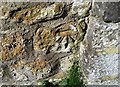
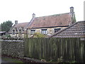
Ordnance Survey Cut Mark
This OS cut mark can be found on No30 Dundry Lane. It marks a point 104.129m above mean sea level.
Image: © Adrian Dust
Taken: 16 Mar 2020
0.04 miles
2
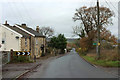
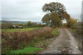
Dundry Lane
Seen dropping through Barrow Common from the bend where Image] and Image] were taken. A similar view to Image The footpath is number LA7 31/10.
Image: © Derek Harper
Taken: 25 Nov 2019
0.08 miles
3
Dundry Lane, near Barrow Tanks
On the telegraph pole there is a sign pointing to the footpath to Barrow Tanks.
Image: © John Lord
Taken: 21 Dec 2011
0.09 miles
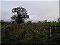
5
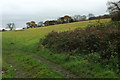
Track from Dundry Lane
Although the trees and hedges alongside it suggest it has been around for a long time, this (private) field access track fails to appear on the 1:25000 map. It leads to some farm buildings as well as several fields.
Image: © Derek Harper
Taken: 25 Nov 2019
0.10 miles
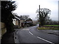
7
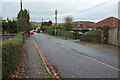
Dundry Lane
Dropping between houses at Barrow Common to meet the A38, where the junction's old signpost Image] Image is visible.
Image: © Derek Harper
Taken: 25 Nov 2019
0.13 miles
8
Hillside field by Dundry Lane
To the right of the scene in Image The Monarch's Way follows a footpath along the upper edge of the field beside the trees.
Image: © Derek Harper
Taken: 25 Nov 2019
0.14 miles
9
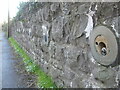
Holding back the Bridgwater Road
The A38 runs in between the Barrow Tanks reservoirs and in so doing passes some earthy revetments. Although not backing onto a reservoir, this part suffers from a lot of water issuing from the land. As this makes the walls rather unstable, measures have been taken to retain its position. Large bolts hold the wall upright.
Image: © Neil Owen
Taken: 10 Nov 2020
0.14 miles
10
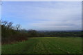
The Monarch's Way leaving Dundry Hill
Leaving the ridges and valleys to the north of the Mendips, and heading towards Bristol in the distance
Image: © Tim Heaton
Taken: 9 Feb 2016
0.16 miles