IMAGES TAKEN NEAR TO
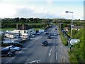
Bridgwater Road, BRISTOL, BS40 9XA
Introduction
This page details the photographs taken nearby to Bridgwater Road, BS40 9XA by members of the Geograph project.
The Geograph project started in 2005 with the aim of publishing, organising and preserving representative images for every square kilometre of Great Britain, Ireland and the Isle of Man.

There are currently over 7.5m images from over14,400 individuals and you can help contribute to the project by visiting https://www.geograph.org.uk
Image Map
Images are licensed for reuse under creativecommons.org/licenses/by-sa/2.0
Notes
- Clicking on the map will re-center to the selected point.
- The higher the marker number, the further away the image location is from the centre of the postcode.
Image Listing (95 Images Found)
Images are licensed for reuse under creativecommons.org/licenses/by-sa/2.0
Image
Details
Distance
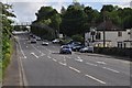
1
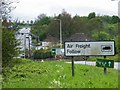
A38 to Bristol Airport
Viewed from Potters Hill. The Airport junction is on the horizon.
Image: © Thomas Nugent
Taken: 27 Apr 2009
0.02 miles
2
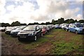
Lulsgate Bottom : Car Park
A car park in a field at Lulsgate Bottom in North Somerset.
Image: © Lewis Clarke
Taken: 13 Jun 2013
0.04 miles
3
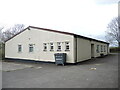
Felton village hall
A fairly large, if plain, hall for the village. It began life in 1931 when Mr. J. Falconar Fry of the Quaker chocolate family gave the land for the hall to the people of Downside and Felton. It was funded largely by subscriptions and donations by the villagers; the hall was re-roofed in 1950 and refurbished in 2000.
Image: © Neil Owen
Taken: 18 Apr 2022
0.04 miles
4
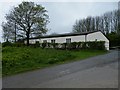
Felton Village Hall
Just off West Lane by the A38.
Image: © Thomas Nugent
Taken: 27 Apr 2009
0.04 miles
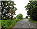
5
Lulsgate Bottom : The A38
A busy road heading through Lulsgate Bottom in North Somerset.
Image: © Lewis Clarke
Taken: 13 Jun 2013
0.05 miles
6
Wooden sculpture on the side of West Lane
Image: © Roger Cornfoot
Taken: 29 May 2019
0.05 miles
7
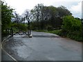
West Lane cattle grid
At the A38 junction in Potters Hill.
Image: © Thomas Nugent
Taken: 27 Apr 2009
0.05 miles
8

Lulsgate Bottom : Grassy Car Park
A grassy car park in a field at Lulsgate Bottom.
Image: © Lewis Clarke
Taken: 13 Jun 2013
0.06 miles
9
A38 to Bristol Airport
The airport junction is just beyond the footbridge.
Image: © Thomas Nugent
Taken: 27 Apr 2009
0.06 miles
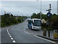
10
The A38 road
Image: © Thomas Nugent
Taken: 8 May 2009
0.07 miles