IMAGES TAKEN NEAR TO
Nempnett Thrubwell, Chew Stoke, BRISTOL, BS40 8YL
Introduction
This page details the photographs taken nearby to BS40 8YL by members of the Geograph project.
The Geograph project started in 2005 with the aim of publishing, organising and preserving representative images for every square kilometre of Great Britain, Ireland and the Isle of Man.

There are currently over 7.5m images from over14,400 individuals and you can help contribute to the project by visiting https://www.geograph.org.uk
Image Map (Loading...)


Getting Data...Please wait
Leaflet Map data © OpenStreetMap
Images are licensed for reuse under creativecommons.org/licenses/by-sa/2.0
Notes
- Clicking on the map will re-center to the selected point.
- The higher the marker number, the further away the image location is from the centre of the postcode.
Image Listing (22 Images Found)
Images are licensed for reuse under creativecommons.org/licenses/by-sa/2.0
Image
Details
Distance
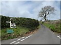
1
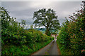
Nempnett Thrubwell : Country Lane
A road heads through the countryside.
Image: © Lewis Clarke
Taken: 23 Jul 2020
0.09 miles
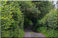
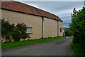
2
Nempnett Thrubwell : Country Lane
A road heads through the countryside.
Image: © Lewis Clarke
Taken: 23 Jul 2020
0.10 miles
3
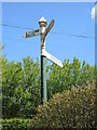
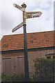
Signpost at the top of Nempnett Street
A typical Somerset style post with an arm for the village hall in a different typeface, indeed looking like it is a second layer of signage.
In the nineteenth century this junction was known as Cuckoo's Nest.
Image: © Neil Owen
Taken: 7 May 2021
0.13 miles
4
Old Direction Sign - Signpost, Nempnett Thrubwell parish
Pyramid finial - 4 arms; Somerset SCC pyramid by the UC road, in parish of Nempnett Thrubwell (Bath and North East Somerset District), junction of two lanes Southeast of Nempnett Farm, between the farm and Highlands.
Surveyed
Milestone Society National ID: SO_ST5260A
Image: © Milestone Society
Taken: Unknown
0.13 miles
5
Nempnett Thrubwell : Country Lane
A road heads through the countryside.
Image: © Lewis Clarke
Taken: 23 Jul 2020
0.14 miles
6
Nempnett Thrubwell : Country Lane
A road heads through the countryside.
Image: © Lewis Clarke
Taken: 23 Jul 2020
0.14 miles
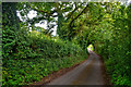
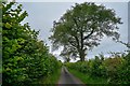
7
Nempnett Thrubwell : Country Lane
The lane passes Rock House.
Image: © Lewis Clarke
Taken: 23 Jul 2020
0.15 miles
8
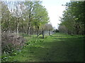
A new woodland by Oxleaze
A fairly large area of open land is now a managed woodland. The footpath goes through between a fenced section.
Image: © Neil Owen
Taken: 7 May 2021
0.16 miles
9

Footpath with a canopy?
It's not quite a special method of keeping people on the right path - there's a gap between the stile and the frame.
Image: © Neil Owen
Taken: 6 Mar 2012
0.16 miles