IMAGES TAKEN NEAR TO
Knowle Hill, BRISTOL, BS40 8TE
Introduction
This page details the photographs taken nearby to Knowle Hill, BS40 8TE by members of the Geograph project.
The Geograph project started in 2005 with the aim of publishing, organising and preserving representative images for every square kilometre of Great Britain, Ireland and the Isle of Man.

There are currently over 7.5m images from over14,400 individuals and you can help contribute to the project by visiting https://www.geograph.org.uk
Image Map (Loading...)


Getting Data...Please wait
Leaflet Map data © OpenStreetMap
Images are licensed for reuse under creativecommons.org/licenses/by-sa/2.0
Notes
- Clicking on the map will re-center to the selected point.
- The higher the marker number, the further away the image location is from the centre of the postcode.
Image Listing (24 Images Found)
Images are licensed for reuse under creativecommons.org/licenses/by-sa/2.0
Image
Details
Distance
1
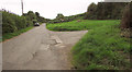
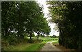
Three Peaks Walk on Knowle Hill
The Way turns off to the right here, onto footpath CL 3/36, from the little lane around the hill to Bishop Sutton.
Image: © Derek Harper
Taken: 18 Sep 2018
0.07 miles
2
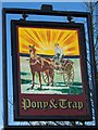
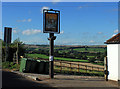
Sign for the Pony and Trap
The trap was a two-wheeled carriage on springs, usually a gig, and with its pony before it was a regular sight in country areas within living memory. The carriage was probably called a trap because it was a rattletrap (also a slang term for 'mouth', now also abbreviated to 'trap').
Image: © Maigheach-gheal
Taken: 17 Jan 2010
0.16 miles
3
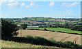
2012 West of north from The Pony and Trap
At New Town.
Moorledge and Moorledge Farm are at the bottom of the valley.
The River Chew passes out of sight further over.
Then comes the southern aspect of Dundry Hill with various transmitters along the top.
Far left in the larger version a group of houses can be seen at the top of the hill, think this is Dundry village but it may be East Dundry.
Image: © Maurice Pullin
Taken: 20 Aug 2012
0.16 miles
4
Footpath, New Town
The footpath takes walkers to Moorledge Farm and is part of the Three Peaks Walk.
Image: © Maigheach-gheal
Taken: 17 Jan 2010
0.16 miles
5
Three Peaks Walk on Knowle Hill
The Walk follows footpath CL 3/36 along this lane which leads to Pitt's Farm and Far End.
Image: © Derek Harper
Taken: 18 Sep 2018
0.16 miles
6
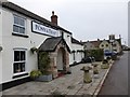
2012 : Sign at The Pony and Trap, New Town
A row of houses with a public house at the end. On the road from Chew Magna to Bishop Sutton.
The Pony and Trap is a 200 year old public house with its own website http://www.theponyandtrap.co.uk/visit-us
Houses at the bottom of the hill are at Moorledge, Dundry Hill is in the distance.
Image: © Maurice Pullin
Taken: 20 Aug 2012
0.16 miles
8
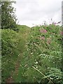
Pathway to Knowle Hill
A rough pathway through the bracken (rose bay willow herb on the right) to the summit of Knowle hill, which reaches 112m in height.
Image: © Sharon Loxton
Taken: 1 Aug 2006
0.17 miles
9
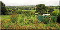
Garden at Pony and Trap
Seen from the car park, with much of the view shown in Image beyond.
Image: © Derek Harper
Taken: 15 Sep 2018
0.17 miles
10
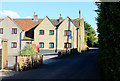
2012 : Dwellings in New Town
Approaching on the road from Chew Magna.
Difficult to age this property, at first sight could have been built in the last ten years, but look at the roof, more like a hundred and that chimney is definitely a recent addition.
Terrific views and right next door to an excellent pub, what more could you ask for.
Image: © Maurice Pullin
Taken: 20 Aug 2012
0.17 miles