IMAGES TAKEN NEAR TO
Brookside, BRISTOL, BS40 8AB
Introduction
This page details the photographs taken nearby to Brookside, BS40 8AB by members of the Geograph project.
The Geograph project started in 2005 with the aim of publishing, organising and preserving representative images for every square kilometre of Great Britain, Ireland and the Isle of Man.

There are currently over 7.5m images from over14,400 individuals and you can help contribute to the project by visiting https://www.geograph.org.uk
Image Map
Images are licensed for reuse under creativecommons.org/licenses/by-sa/2.0
Notes
- Clicking on the map will re-center to the selected point.
- The higher the marker number, the further away the image location is from the centre of the postcode.
Image Listing (84 Images Found)
Images are licensed for reuse under creativecommons.org/licenses/by-sa/2.0
Image
Details
Distance
4
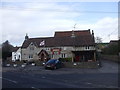
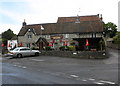
Prince of Waterloo, Winford
Popular pub in the centre of Winford.
Image: © Steve Barnes
Taken: 10 Sep 2010
0.05 miles
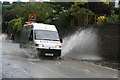
6
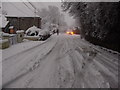
Unexpected Snow 6th February 2009
Cold winter morning in Winford
Image: © jeff lewis
Taken: 6 Feb 2009
0.07 miles
7
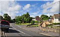
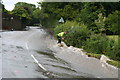
Winford : Barrow Lane
The B3130 heading through the village of Winford in North Somerset.
Image: © Lewis Clarke
Taken: 13 Jun 2013
0.08 miles
8
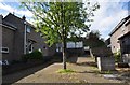
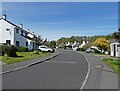
Winford : Houses
Houses between Barrow Lane and Felton Lane in Winford.
Image: © Lewis Clarke
Taken: 13 Jun 2013
0.08 miles
10
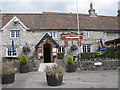
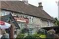
Prince of Waterloo, Winford
Sits on the edge of a grid square.
Image: © Pauline E
Taken: 29 Aug 2009
0.09 miles