IMAGES TAKEN NEAR TO
Charterhouse, Blagdon, BRISTOL, BS40 7XS
Introduction
This page details the photographs taken nearby to BS40 7XS by members of the Geograph project.
The Geograph project started in 2005 with the aim of publishing, organising and preserving representative images for every square kilometre of Great Britain, Ireland and the Isle of Man.

There are currently over 7.5m images from over14,400 individuals and you can help contribute to the project by visiting https://www.geograph.org.uk
Image Map
Images are licensed for reuse under creativecommons.org/licenses/by-sa/2.0
Notes
- Clicking on the map will re-center to the selected point.
- The higher the marker number, the further away the image location is from the centre of the postcode.
Image Listing (12 Images Found)
Images are licensed for reuse under creativecommons.org/licenses/by-sa/2.0
Image
Details
Distance
1
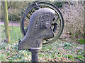
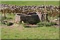
Old Water Pump
In Charterhouse near Manor Farm. A chain pump, certainly used for pumping water, but also used on farms for pumping slurry. A chain pump doesn't use valves - and hence needs little or no maintenance - but has a series of disks on a continuous chain that are wound down into the water source and then lift the water up through the delivery pipe. Simple but effective, and is based on a design that's thousands of years old, origination in China, I think, where they tied rags to the chain.
The pump in this picture has lost its chain, but you can see the chain wheel with its slots that would have accommodated the disks.
Image: © Rick Crowley
Taken: 14 Mar 2009
0.01 miles
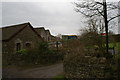
3
Entrance, Mendip Wood Shavings factory
Image: © Roger Cornfoot
Taken: 10 Oct 2018
0.09 miles
4
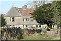
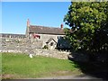
Manor Farm, Charterhouse
Reputed to be built in the 17th century and may be on the site of a Carthusian settlement. Apparently the word Charterhouse is the English name for a Carthusian monastery.
Image: © Rick Crowley
Taken: 14 Mar 2009
0.11 miles
6
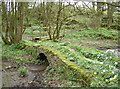
Miniature bridge
The footpath through the grounds of Manor Farm take in this attractive footbridge; a more modern wood version in the background crosses what is normally a marshy patch beside the ponds.
Image: © Neil Owen
Taken: 4 Apr 2017
0.13 miles
7
Charterhouse Packhorse Bridge
https://historicengland.org.uk/listing/the-list/list-entry/1345130?section=official-list-entry
Image: © Sandy Gerrard
Taken: 3 Jun 2024
0.13 miles
8
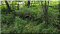
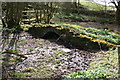
Entrance to Manor Farm swallet
The top of a shaft leading into the cave system.
Image: © Guy Wareham
Taken: 5 Apr 2009
0.14 miles
9
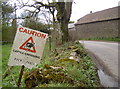
Caution - cattle crossing!
A dynamic image of a cow warns road users.
Image: © Neil Owen
Taken: 4 Apr 2017
0.14 miles
10
Footbridges at Charterhouse
Old and a modern footbridges, on the path to Velvet Bottom, near Manor Farm.
Image: © Guy Wareham
Taken: 5 Apr 2009
0.15 miles