IMAGES TAKEN NEAR TO
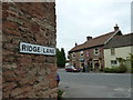
Ridge Lane, BRISTOL, BS40 6ED
Introduction
This page details the photographs taken nearby to Ridge Lane, BS40 6ED by members of the Geograph project.
The Geograph project started in 2005 with the aim of publishing, organising and preserving representative images for every square kilometre of Great Britain, Ireland and the Isle of Man.

There are currently over 7.5m images from over14,400 individuals and you can help contribute to the project by visiting https://www.geograph.org.uk
Image Map
Images are licensed for reuse under creativecommons.org/licenses/by-sa/2.0
Notes
- Clicking on the map will re-center to the selected point.
- The higher the marker number, the further away the image location is from the centre of the postcode.
Image Listing (91 Images Found)
Images are licensed for reuse under creativecommons.org/licenses/by-sa/2.0
Image
Details
Distance
1
Three off the leash on the Limestone Link (122)
In which three middle aged men who have known each other for forty years embark on an intrepid yomp across a path that links the Cotswold Way with the West Mendip Way http://en.wikipedia.org/wiki/Limestone_Link
Image: © Basher Eyre
Taken: 15 Sep 2012
0.03 miles
2

Three off the leash on the Limestone Link (121)
In which three middle aged men who have known each other for forty years embark on an intrepid yomp across a path that links the Cotswold Way with the West Mendip Way http://en.wikipedia.org/wiki/Limestone_Link
Image: © Basher Eyre
Taken: 15 Sep 2012
0.03 miles
3
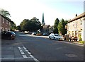
The A368 through West Harptree
Taken in strong afternoon sun in late September; the temperature at 4.45pm was still 21C, hence the shirtsleeved drinkers outside The Crown.
Image: © David Gearing
Taken: 28 Sep 2011
0.04 miles
4
Three off the leash on the Limestone Link (123)
In which three middle aged men who have known each other for forty years embark on an intrepid yomp across a path that links the Cotswold Way with the West Mendip Way http://en.wikipedia.org/wiki/Limestone_Link
Image: © Basher Eyre
Taken: 15 Sep 2012
0.05 miles
5
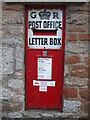
Priority over the weekend
West Harptree's enamelled letterbox, now a priority box in these Covid days.
Image: © Neil Owen
Taken: 29 Apr 2021
0.05 miles
6
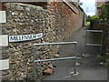
Millennium Way
A short alley to the play area at the back of West Harptree. The path itself is many years old, though.
Image: © Neil Owen
Taken: 29 Apr 2021
0.05 miles
7
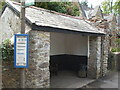
A royal shelter
This bus shelter in West Harptree was erected to commemorate the coronation of Queen Elizabeth II on 2nd June, 1953.
Image: © Neil Owen
Taken: 29 Apr 2021
0.05 miles
8
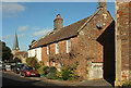
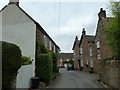
West Harptree
Beyond the two cottages is a sign for the (almost hidden) Crown Inn, with St Mary's church Image] visible in the background.
Image: © Derek Harper
Taken: 27 Feb 2022
0.05 miles
9
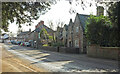
Old School House, West Harptree
On the A368 as it approaches the centre of the village. The school was built in 1852.
Image: © Derek Harper
Taken: 27 Feb 2022
0.05 miles
10
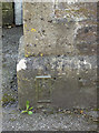
West Harptree flush bracket
On the old school house is an Ordnance Survey flush bracket, dating from the Third Levelling in 1955. See Image] for a wider view and http://www.bench-marks.org.uk/bm15605 for the entry in the Benchmark Database.
Image: © Neil Owen
Taken: 3 Jun 2013
0.05 miles