IMAGES TAKEN NEAR TO
East Harptree, BRISTOL, BS40 6DQ
Introduction
This page details the photographs taken nearby to BS40 6DQ by members of the Geograph project.
The Geograph project started in 2005 with the aim of publishing, organising and preserving representative images for every square kilometre of Great Britain, Ireland and the Isle of Man.

There are currently over 7.5m images from over14,400 individuals and you can help contribute to the project by visiting https://www.geograph.org.uk
Image Map (Loading...)


Getting Data...Please wait
Leaflet Map data © OpenStreetMap
Images are licensed for reuse under creativecommons.org/licenses/by-sa/2.0
Notes
- Clicking on the map will re-center to the selected point.
- The higher the marker number, the further away the image location is from the centre of the postcode.
Image Listing (3 Images Found)
Images are licensed for reuse under creativecommons.org/licenses/by-sa/2.0
Image
Details
Distance
1
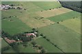
Circular features near Swallet Farm, NE of Priddy: aerial 2019
Swallet Farm takes its name from the sink hole, the Devil's Punchbowl, which is off-shot centre-left.
Image: © Chris
Taken: 8 Aug 2019
0.12 miles
2
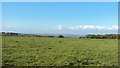
The Devil's Punch Bowl
Looking across and down into the Devil's Punch Bowl from triangulation pillar on Smithans Hill.
Image: © Howard
Taken: 12 May 2011
0.13 miles
3
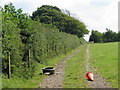
Track along the edge of a field in the Mendips
Image: © Sarah Charlesworth
Taken: 16 Aug 2010
0.18 miles