IMAGES TAKEN NEAR TO
Wallace Lane, BRISTOL, BS40 6BU
Introduction
This page details the photographs taken nearby to Wallace Lane, BS40 6BU by members of the Geograph project.
The Geograph project started in 2005 with the aim of publishing, organising and preserving representative images for every square kilometre of Great Britain, Ireland and the Isle of Man.

There are currently over 7.5m images from over14,400 individuals and you can help contribute to the project by visiting https://www.geograph.org.uk
Image Map
Images are licensed for reuse under creativecommons.org/licenses/by-sa/2.0
Notes
- Clicking on the map will re-center to the selected point.
- The higher the marker number, the further away the image location is from the centre of the postcode.
Image Listing (6 Images Found)
Images are licensed for reuse under creativecommons.org/licenses/by-sa/2.0
Image
Details
Distance
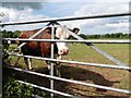
1
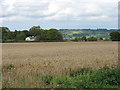
Farmland and house
Farmland and house viewed from Wallance Lane in East Harptree.
Image: © Philip Halling
Taken: 15 Feb 2018
0.04 miles
2
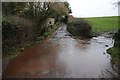
A temporary ford
I'm sure this isn't a ford on Wallace Lane in East Harptree, after heavy rainfall the water has flooded this road as it flows across it.
Image: © Philip Halling
Taken: 15 Feb 2018
0.04 miles
5
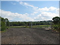
Double gates into field near East Harptree
Image: © Sarah Charlesworth
Taken: 16 Aug 2010
0.21 miles