IMAGES TAKEN NEAR TO
West Harptree Road, BRISTOL, BS40 6BQ
Introduction
This page details the photographs taken nearby to West Harptree Road, BS40 6BQ by members of the Geograph project.
The Geograph project started in 2005 with the aim of publishing, organising and preserving representative images for every square kilometre of Great Britain, Ireland and the Isle of Man.

There are currently over 7.5m images from over14,400 individuals and you can help contribute to the project by visiting https://www.geograph.org.uk
Image Map (Loading...)


Getting Data...Please wait
Leaflet Map data © OpenStreetMap
Images are licensed for reuse under creativecommons.org/licenses/by-sa/2.0
Notes
- Clicking on the map will re-center to the selected point.
- The higher the marker number, the further away the image location is from the centre of the postcode.
Image Listing (15 Images Found)
Images are licensed for reuse under creativecommons.org/licenses/by-sa/2.0
Image
Details
Distance
1
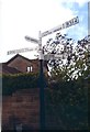
Old Direction Sign - Signpost by the B3114, Townsend crossroads
Lost finial - 4 arms; Somerset SCC pyramid by the B3114, in parish of East Harptree (Bath And North East Somerset District), Townsend crossroads, West Harptree Road, junction with High Street and lane to South Widcombe.
Surveyed
Milestone Society National ID: SO_ST5656B.
Image: © Milestone Society
Taken: Unknown
0.11 miles
2
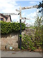
At the crossroads in East Harptree
A range of different styles of arms on the Somerset style post, albeit without the pyramidal finial. The B roads have square ends, the minor roads have angle points and the East Harptree arm looks a different age and typography.
Image: © Neil Owen
Taken: 29 Apr 2021
0.11 miles
3
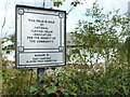
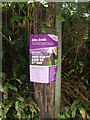
Trusting in the fields
East Harptree playing fields is under the wing of the N.P.F.A. The charity was founded in 1925 by Brigadier-General Reginald Kentish and the Duke of York, later King George VI. Today the Fields in Trust charity aims to provide open space and support for people of all ages to enjoy.
Image: © Neil Owen
Taken: 29 Apr 2021
0.12 miles
4
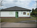
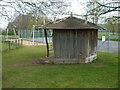
East Harptree playing field pavilion
The area serving the village was converted from farmland less than a generation ago, and was then renovated in July 2018. The grounds are held by the National Playing Fields Association.
Image: © Neil Owen
Taken: 29 Apr 2021
0.12 miles
5
Poling day on a pole
Early May and the local elections are as traditional as the flowers. A hopeful candidate makes this telegraph pole a place to advertise. When the votes were counted, Mr Smith was well down the order.
Image: © Neil Owen
Taken: 29 Apr 2021
0.13 miles
6
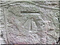
Benchmark along Coley Road
As the main road leaves Townsend and heads towards Coley it has to cross the stream at Harptree Bridge. This cutmark can be seen to the left of the inscription of its rebuilding (1922). See https://www.bench-marks.org.uk/bm147876 for the entry in the Benchmark Database and Image] for a wide shot.
Image: © Neil Owen
Taken: 29 Apr 2021
0.13 miles
7
Harptree Bridge
This bridge over the stream in Townsend, near East Harptree, was rebuilt in 1922. It happens to have a benchmark - see Image
Image: © Neil Owen
Taken: 29 Apr 2021
0.14 miles
8
East Harptree recreation ground
A small village is blessed with a good range of things, for young and old.
Image: © Neil Owen
Taken: 29 Apr 2021
0.16 miles
9
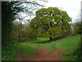
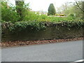
Earthen bank by the Molly Brook
The tree is a relative newcomer; the earth mound is the remnant of an old quarry and limekiln from about a century or more ago.
Image: © Neil Owen
Taken: 29 Apr 2021
0.20 miles
10
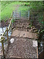
A mixture spanning the brook
It seem many attempts have been made to make some sort of footbridge over the Molly Brook.
Image: © Neil Owen
Taken: 29 Apr 2021
0.21 miles