IMAGES TAKEN NEAR TO
Coley Road, BRISTOL, BS40 6AL
Introduction
This page details the photographs taken nearby to Coley Road, BS40 6AL by members of the Geograph project.
The Geograph project started in 2005 with the aim of publishing, organising and preserving representative images for every square kilometre of Great Britain, Ireland and the Isle of Man.

There are currently over 7.5m images from over14,400 individuals and you can help contribute to the project by visiting https://www.geograph.org.uk
Image Map (Loading...)


Getting Data...Please wait
Leaflet Map data © OpenStreetMap
Images are licensed for reuse under creativecommons.org/licenses/by-sa/2.0
Notes
- Clicking on the map will re-center to the selected point.
- The higher the marker number, the further away the image location is from the centre of the postcode.
Image Listing (16 Images Found)
Images are licensed for reuse under creativecommons.org/licenses/by-sa/2.0
Image
Details
Distance
1
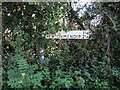
Not many travellers
This signpost lies close to Coley and fortunately is not on a particularly busy route. A more direct road is just metres away and bypasses Coley.
Image: © Neil Owen
Taken: 11 Oct 2024
0.04 miles
2
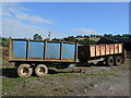
Trailers, parked
A couple of farm trailers have a moment's rest.
Image: © Neil Owen
Taken: 11 Oct 2024
0.07 miles
3
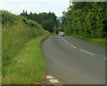
2012 : B3114 the Coley bypass
Heading to West Harptree then on to Chew Stoke.
Image: © Maurice Pullin
Taken: 18 Jun 2012
0.09 miles
4
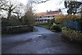
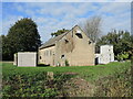
Bridge crossing the River Chew
Bridge crossing the River Chew at Coley, at the time of the picture the river was in spate after heavy overnight rain. Building workers are already working on the house under scaffolding despite the early hour.
Image: © Philip Halling
Taken: 15 Feb 2018
0.14 miles
5
Electricity and water can mix
The buildings house a pumping station and an electricity substation.
Image: © Neil Owen
Taken: 11 Oct 2024
0.14 miles
6
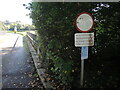
A general warning
A warning sign without a symbol (graffiti notwithstanding) refers to drivers of heavy vehicles. Any such should be wary of the weight restrictions on the reservoir embankments.
Image: © Neil Owen
Taken: 11 Oct 2024
0.17 miles
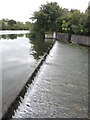
7
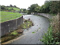
Lower Reservoir spillway
The Chew's temporary gathering in the two reservoirs is over - it flows on down to Chew Lake, where it will gather for much longer.
Image: © Neil Owen
Taken: 11 Oct 2024
0.19 miles
8
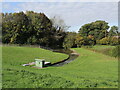
Setting off for another reservoir
Leaving Litton's two reservoirs, the Chew makes its way for about 3km (1.9 miles) for the much larger Chew Lake reservoir.
Image: © Neil Owen
Taken: 11 Oct 2024
0.19 miles
9
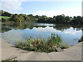
A corner of the reservoir
Litton Lower Reservoir has a square return to the dam wall. The area is beautifully quiet and unspoiled.
Image: © Neil Owen
Taken: 11 Oct 2024
0.20 miles
10
Spillway weir
Litton Lower Reservoir is regulated by this weir, whereupon water flows down the spillway and a right-angle bend.
Image: © Neil Owen
Taken: 11 Oct 2024
0.22 miles