IMAGES TAKEN NEAR TO
Eastwood, BRISTOL, BS40 6AJ
Introduction
This page details the photographs taken nearby to Eastwood, BS40 6AJ by members of the Geograph project.
The Geograph project started in 2005 with the aim of publishing, organising and preserving representative images for every square kilometre of Great Britain, Ireland and the Isle of Man.

There are currently over 7.5m images from over14,400 individuals and you can help contribute to the project by visiting https://www.geograph.org.uk
Image Map (Loading...)


Getting Data...Please wait
Leaflet Map data © OpenStreetMap
Images are licensed for reuse under creativecommons.org/licenses/by-sa/2.0
Notes
- Clicking on the map will re-center to the selected point.
- The higher the marker number, the further away the image location is from the centre of the postcode.
Image Listing (11 Images Found)
Images are licensed for reuse under creativecommons.org/licenses/by-sa/2.0
Image
Details
Distance
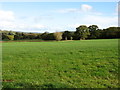
2
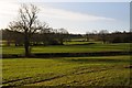
Farmland near East Harptree
Fields to the east of the village of East Harptree.
Image: © Philip Halling
Taken: 15 Feb 2018
0.11 miles
5
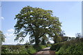
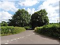
Country Lane on the Mendips
Image: © Adrian and Janet Quantock
Taken: 5 May 2006
0.16 miles
6
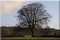
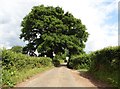
Tree in a hedgerow
Tree (probably beech) in a hedgerow to the east of East Harptree.
Image: © Philip Halling
Taken: 15 Feb 2018
0.16 miles
9
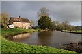
Houses overlooking a pool
Houses overlooking a pool near East Harptree.
Image: © Philip Halling
Taken: 15 Feb 2018
0.24 miles
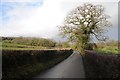
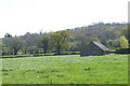
10
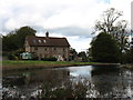
The house at the entrance to Eastwood Manor Farm
A small stream is here dammed on several occasions as it flows north-east, finally joining the River Chew upstream of the Chew Valley Lake.
Image: © David Purchase
Taken: 26 Oct 2011
0.24 miles