IMAGES TAKEN NEAR TO
Redhill, BRISTOL, BS40 5TD
Introduction
This page details the photographs taken nearby to BS40 5TD by members of the Geograph project.
The Geograph project started in 2005 with the aim of publishing, organising and preserving representative images for every square kilometre of Great Britain, Ireland and the Isle of Man.

There are currently over 7.5m images from over14,400 individuals and you can help contribute to the project by visiting https://www.geograph.org.uk
Image Map (Loading...)


Getting Data...Please wait
Leaflet Map data © OpenStreetMap
Images are licensed for reuse under creativecommons.org/licenses/by-sa/2.0
Notes
- Clicking on the map will re-center to the selected point.
- The higher the marker number, the further away the image location is from the centre of the postcode.
Image Listing (16 Images Found)
Images are licensed for reuse under creativecommons.org/licenses/by-sa/2.0
Image
Details
Distance
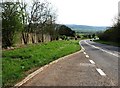
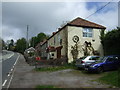
2
The A38
On the A38 at Redhill, near Bristol airport.
Image: © Robert Ashby
Taken: 16 Aug 2014
0.09 miles
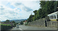
6
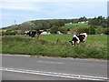
Grass is always greener
The grass must be tastier on the other side of the fence, along the verge of the busy A38.
Image: © MD
Taken: 25 Oct 2008
0.13 miles
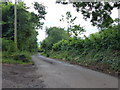
10
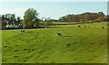
Farmland at Redhill
With Chancellor's Cottage on the left, and a similar scene to Image], but with a clearer view of an unnamed wood up the hill on the right.
Image: © Derek Harper
Taken: 17 Apr 2016
0.18 miles