IMAGES TAKEN NEAR TO
Wrington, BRISTOL, BS40 5SR
Introduction
This page details the photographs taken nearby to BS40 5SR by members of the Geograph project.
The Geograph project started in 2005 with the aim of publishing, organising and preserving representative images for every square kilometre of Great Britain, Ireland and the Isle of Man.

There are currently over 7.5m images from over14,400 individuals and you can help contribute to the project by visiting https://www.geograph.org.uk
Image Map
Images are licensed for reuse under creativecommons.org/licenses/by-sa/2.0
Notes
- Clicking on the map will re-center to the selected point.
- The higher the marker number, the further away the image location is from the centre of the postcode.
Image Listing (3 Images Found)
Images are licensed for reuse under creativecommons.org/licenses/by-sa/2.0
Image
Details
Distance
1
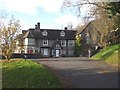
Barley Wood, from the east
Barley Wood was originally the home of Hannah More, whom Anne Stott, in her excellent biography, calls "the first Victorian". Of recent years it has been a rehabilitation centre, but appears now to be for sale.
Image: © John Lord
Taken: 19 Nov 2008
0.20 miles
2
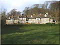
Barley Wood, Wrington, from the south
Barley Wood was originally built by Hannah More, a bust of whom is in Wrington parish church. The dustjacket of the excellent biography by Anne Stott, "Hannah More, the first Victorian" (OUP 2003), gives this assessment of her:"Hannah More was a public figure at a time when domesticity was regarded as a woman's chief virtue. Her career as playwright, bluestocking, Evangelical educationalist, anti-slavery campaigner, political writer and novelist made her one of the most influential women of her day."
The house subsequently belonged to members of the Wills family, the tobacco manufacturers.
Image: © John Lord
Taken: 19 Nov 2008
0.21 miles
3
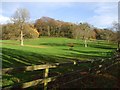
Pasture and woodland beside the drive to Barley Wood, Wrington
Image: © John Lord
Taken: 19 Nov 2008
0.22 miles