IMAGES TAKEN NEAR TO
Rickyard Road, BRISTOL, BS40 5RR
Introduction
This page details the photographs taken nearby to Rickyard Road, BS40 5RR by members of the Geograph project.
The Geograph project started in 2005 with the aim of publishing, organising and preserving representative images for every square kilometre of Great Britain, Ireland and the Isle of Man.

There are currently over 7.5m images from over14,400 individuals and you can help contribute to the project by visiting https://www.geograph.org.uk
Image Map (Loading...)


Getting Data...Please wait
Leaflet Map data © OpenStreetMap
Images are licensed for reuse under creativecommons.org/licenses/by-sa/2.0
Notes
- Clicking on the map will re-center to the selected point.
- The higher the marker number, the further away the image location is from the centre of the postcode.
Image Listing (52 Images Found)
Images are licensed for reuse under creativecommons.org/licenses/by-sa/2.0
Image
Details
Distance
1
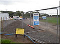
Path closed as the land is cleared
Unusual to see a public footpath named in such manner, but the land to the east of Rickyard Road is under the bulldozer. Flooding prevention works are about to start, once any archaeological investigations have been completed.
Image: © Neil Owen
Taken: 23 Aug 2018
0.07 miles
2
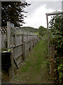
Path to Rickyard Road
Only a short straight, but based on an old path that used to go to Ryding's Farm - which is now lost to housing.
Image: © Neil Owen
Taken: 23 Aug 2018
0.08 miles
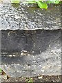
3
Rivet in Silver Street
A benchmark, as listed in the Benchmark Database: https://www.bench-marks.org.uk/bm99038 , on a bridge parapet in Wrington. See Image] for a wider view.
Image: © Neil Owen
Taken: 23 Aug 2018
0.11 miles
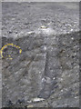
4
Ordnance Survey Rivet
This OS rivet can be found on the SW parapet of the bridge. It marks a point 19.630m above mean sea level.
Image: © Adrian Dust
Taken: 25 Jul 2022
0.11 miles
5
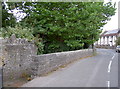
Bridge on Silver Street
A small stream trickles underneath - see Image] for a quick look and Image] for a benchmark on the near parapet.
Image: © Neil Owen
Taken: 23 Aug 2018
0.11 miles
6
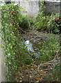
The stream behind the bridge
Wrington lies across the lower slopes of North Somerset and has many water courses. This little fellow runs down towards Cox's Green before greeting the Langford Brook. See Image] for a wider view through the housing.
Image: © Neil Owen
Taken: 23 Aug 2018
0.11 miles
7
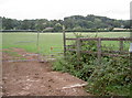
Back up to Long Lane
The footpath here has not been temporarily closed due to the ongoing flood prevention works taking place opposite. Cross the stream and negotiate the railings cobbled together and head uphill to the road. Mind the sheep, though.
Image: © Neil Owen
Taken: 23 Aug 2018
0.12 miles
8
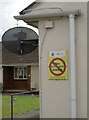
Doorsteppers are not welcome!
Possibly adding Jehovah's Witnesses and political canvassers too. A quiet residential area in Wrington for mainly elderly people.
Image: © Neil Owen
Taken: 29 Aug 2018
0.12 miles
9
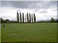
Croquet at Wrington
The sports facility allows the villagers plenty of fresh air and the chance to play some more varied games.
Image: © Neil Owen
Taken: 23 Aug 2018
0.13 miles
10
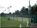
Tennis in Wrington
Two courts at the sports ground.
Image: © Neil Owen
Taken: 23 Aug 2018
0.13 miles