IMAGES TAKEN NEAR TO
Redhill, BRISTOL, BS40 5RP
Introduction
This page details the photographs taken nearby to BS40 5RP by members of the Geograph project.
The Geograph project started in 2005 with the aim of publishing, organising and preserving representative images for every square kilometre of Great Britain, Ireland and the Isle of Man.

There are currently over 7.5m images from over14,400 individuals and you can help contribute to the project by visiting https://www.geograph.org.uk
Image Map (Loading...)


Getting Data...Please wait
Leaflet Map data © OpenStreetMap
Images are licensed for reuse under creativecommons.org/licenses/by-sa/2.0
Notes
- Clicking on the map will re-center to the selected point.
- The higher the marker number, the further away the image location is from the centre of the postcode.
Image Listing (8 Images Found)
Images are licensed for reuse under creativecommons.org/licenses/by-sa/2.0
Image
Details
Distance
1
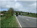
Red Hill (A38)
Heading north east towards Bristol.
Image: © JThomas
Taken: 10 May 2013
0.03 miles
3
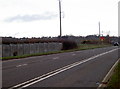
Slow down!
The A38 at Lye Cross as it heads steeply up towards Redhill. To the far left of shot is a forlorn looking milepost; sadly the plate is now missing but it would have told the traveller that it is nine miles to Bristol and seven to Cross. A pivot benchmark can just still be made out on it - see Image
Image: © Neil Owen
Taken: 23 Jan 2012
0.12 miles
4
Grass is always greener
The grass must be tastier on the other side of the fence, along the verge of the busy A38.
Image: © MD
Taken: 25 Oct 2008
0.12 miles
5
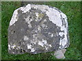
Faint arrows
The top of the 9th milestone from Bristol at Lye Cross also had a pivot benchmark on its top. However, the years have not been kind and the arrows are difficult to see. See http://www.bench-marks.org.uk/bm28984 for the entry in the Benchmark Database and Image] for a location view.
Image: © Neil Owen
Taken: 23 Jan 2012
0.15 miles
6
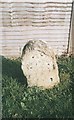
Old Milestone, A38, Red Hill, Lye Cross
The milestone is located on the grass verge in front of a wooden fence, on the north side of the road. Parish of Wrington (North Somerset District). Stone post (plate lost), Bristol iron plate design, erected by the Bristol turnpike trust in the 18th century.
Inscription once read:-
Bristol
9
Cross
7
Carved benchmark and pivot on top
North Somerset HER Listed, NSHER number: MNS6496 https://www.heritagegateway.org.uk/Gateway/Results_Single.aspx?uid=MNS6496&resourceID=1046
Milestone Society National ID: SO_BRCR09
Image: © Janet Dowding
Taken: 15 Apr 2004
0.15 miles
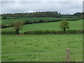
7

Chancellor's Cottage, Redhill
Osborne's retreat, perhaps? On the steep slopes of the hill climbed at Redhill by the A38, from which this was taken. Beyond is Horts Wood on the left.
Image: © Derek Harper
Taken: 17 Apr 2016
0.17 miles
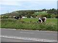
8
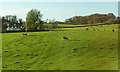
Farmland at Redhill
With Chancellor's Cottage on the left, and a similar scene to Image], but with a clearer view of an unnamed wood up the hill on the right.
Image: © Derek Harper
Taken: 17 Apr 2016
0.18 miles