IMAGES TAKEN NEAR TO
Lye Hole Lane, BRISTOL, BS40 5RN
Introduction
This page details the photographs taken nearby to Lye Hole Lane, BS40 5RN by members of the Geograph project.
The Geograph project started in 2005 with the aim of publishing, organising and preserving representative images for every square kilometre of Great Britain, Ireland and the Isle of Man.

There are currently over 7.5m images from over14,400 individuals and you can help contribute to the project by visiting https://www.geograph.org.uk
Image Map
Images are licensed for reuse under creativecommons.org/licenses/by-sa/2.0
Notes
- Clicking on the map will re-center to the selected point.
- The higher the marker number, the further away the image location is from the centre of the postcode.
Image Listing (13 Images Found)
Images are licensed for reuse under creativecommons.org/licenses/by-sa/2.0
Image
Details
Distance
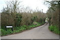
1
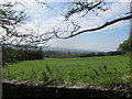
Small South facing meadow adjacent to Lye Hole Lane
Image: © Dr Duncan Pepper
Taken: 5 Sep 2013
0.04 miles
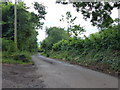
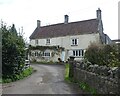
3
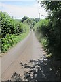
Lye Hole Lane looking downhill and South
Image: © Dr Duncan Pepper
Taken: 5 Sep 2013
0.08 miles
4
Guarding the gate
A male pheasant (Phasianidae sp.) stands in the middle of the gate. On passing closer, it became clear the poor bird had an injured right foot and didn't seem to want to make any sudden movement.
Image: © Neil Owen
Taken: 6 Mar 2012
0.13 miles
6
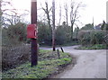
Postbox on the post
A local postbox conveniently situated on a sturdy telegraph pole in the small and largely farming based Lye Hole.
Image: © Neil Owen
Taken: 6 Mar 2012
0.15 miles
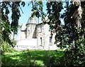
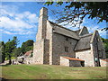
10
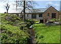
Lye Hole Cottage
Cleverly straddling the stream.
Image: © Roger Cornfoot
Taken: 7 Apr 2022
0.21 miles