IMAGES TAKEN NEAR TO
Hannah More Close, BRISTOL, BS40 5QG
Introduction
This page details the photographs taken nearby to Hannah More Close, BS40 5QG by members of the Geograph project.
The Geograph project started in 2005 with the aim of publishing, organising and preserving representative images for every square kilometre of Great Britain, Ireland and the Isle of Man.

There are currently over 7.5m images from over14,400 individuals and you can help contribute to the project by visiting https://www.geograph.org.uk
Image Map
Images are licensed for reuse under creativecommons.org/licenses/by-sa/2.0
Notes
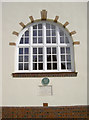
- Clicking on the map will re-center to the selected point.
- The higher the marker number, the further away the image location is from the centre of the postcode.
Image Listing (97 Images Found)
Images are licensed for reuse under creativecommons.org/licenses/by-sa/2.0
Image
Details
Distance
1
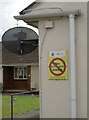
Doorsteppers are not welcome!
Possibly adding Jehovah's Witnesses and political canvassers too. A quiet residential area in Wrington for mainly elderly people.
Image: © Neil Owen
Taken: 29 Aug 2018
0.04 miles
2
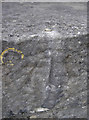
Rivet in Silver Street
A benchmark, as listed in the Benchmark Database: https://www.bench-marks.org.uk/bm99038 , on a bridge parapet in Wrington. See Image] for a wider view.
Image: © Neil Owen
Taken: 23 Aug 2018
0.04 miles
3
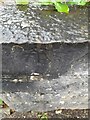
Ordnance Survey Rivet
This OS rivet can be found on the SW parapet of the bridge. It marks a point 19.630m above mean sea level.
Image: © Adrian Dust
Taken: 25 Jul 2022
0.04 miles
4
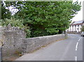
Bridge on Silver Street
A small stream trickles underneath - see Image] for a quick look and Image] for a benchmark on the near parapet.
Image: © Neil Owen
Taken: 23 Aug 2018
0.04 miles
5
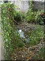
The stream behind the bridge
Wrington lies across the lower slopes of North Somerset and has many water courses. This little fellow runs down towards Cox's Green before greeting the Langford Brook. See Image] for a wider view through the housing.
Image: © Neil Owen
Taken: 23 Aug 2018
0.04 miles
6
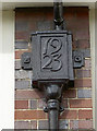
Date on a downpipe
The hall in Wrington bears its date of founding on a gutter downpipe.
Image: © Neil Owen
Taken: 29 Aug 2018
0.05 miles
7
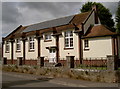
Memorial Hall in Silver Street
The village meeting place since 1923.
Image: © Neil Owen
Taken: 29 Aug 2018
0.05 miles
8
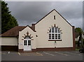
Wrington memorial hall
The foundation stone is dated May 1923.
Image: © Neil Owen
Taken: 23 Aug 2018
0.06 miles
9
A little achievement
The west wall of Wrington's Memorial Hall bears two plaques: one marks the founding of the hall by Mary Monica Cunliffe, widow of Henry Herbert Wills (of tobacco family fame) on May 26th, 1923. The upper plaque confers the award of the old Avon Best Kept Village in 1995. The award was the Wills Cup, rather appropriately.
Image: © Neil Owen
Taken: 29 Aug 2018
0.06 miles
10
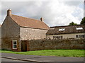
The gasworks are gone
This unremarkable scene in Lawrence Street shows little of the past. Indeed, this was previously the site of Wrington's Gasometer, now a small business place and housing. The gas works would have kept the village in power and light in the nineteenth century, but it had been replaced by other forms of supply by the early 1900s. The works then were used as a smithy initially before more development.
Image: © Neil Owen
Taken: 29 Aug 2018
0.07 miles