IMAGES TAKEN NEAR TO
Lawrence Road, BRISTOL, BS40 5QF
Introduction
This page details the photographs taken nearby to Lawrence Road, BS40 5QF by members of the Geograph project.
The Geograph project started in 2005 with the aim of publishing, organising and preserving representative images for every square kilometre of Great Britain, Ireland and the Isle of Man.

There are currently over 7.5m images from over14,400 individuals and you can help contribute to the project by visiting https://www.geograph.org.uk
Image Map
Images are licensed for reuse under creativecommons.org/licenses/by-sa/2.0
Notes
- Clicking on the map will re-center to the selected point.
- The higher the marker number, the further away the image location is from the centre of the postcode.
Image Listing (117 Images Found)
Images are licensed for reuse under creativecommons.org/licenses/by-sa/2.0
Image
Details
Distance
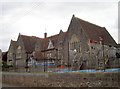
1
Wrington school
For further information see the school website http://www.wringtonprimary.ik.org/
Image: © FollowMeChaps
Taken: 2 Jan 2006
0.04 miles
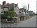
2
Lawrence Road, Wrington
Semis along the south-facing side of a street off Silver Street.
Image: © Derek Harper
Taken: 24 Jan 2023
0.05 miles
3
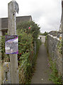
A short walk to Lawrence Road
A path opposite the school joins up with another road. The post doubles up as a handy advertising facility.
Image: © Neil Owen
Taken: 23 Aug 2018
0.05 miles
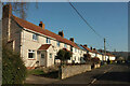
4
Doorsteppers are not welcome!
Possibly adding Jehovah's Witnesses and political canvassers too. A quiet residential area in Wrington for mainly elderly people.
Image: © Neil Owen
Taken: 29 Aug 2018
0.05 miles
5
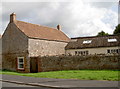
The gasworks are gone
This unremarkable scene in Lawrence Street shows little of the past. Indeed, this was previously the site of Wrington's Gasometer, now a small business place and housing. The gas works would have kept the village in power and light in the nineteenth century, but it had been replaced by other forms of supply by the early 1900s. The works then were used as a smithy initially before more development.
Image: © Neil Owen
Taken: 29 Aug 2018
0.06 miles
6
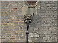
A learned lion?
Unusual to see such ornamentation on a school, you might expect this lion to be on something like a church. However, here it is in Wrington, overlooking the playground - and the only one on the drainpipes.
Image: © Neil Owen
Taken: 29 Aug 2018
0.06 miles
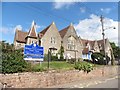
8
Wrington Primary School
First opened on 1st May, 1857. See Image] for a benchmark.
Image: © Neil Owen
Taken: 23 Aug 2018
0.06 miles
9
Benchmark by the bin
Wrington school is well provisioned; a cutmark, as listed in the Benchmark Database: https://www.bench-marks.org.uk/bm99037 , lies on the southeast corner. See Image] for a wider view.
Image: © Neil Owen
Taken: 23 Aug 2018
0.07 miles
10
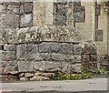
Ordnance Survey Cut Mark
This OS cut mark can be found on the SE angle of the school. It marks a point 26.087m above mean sea level.
Image: © Adrian Dust
Taken: 25 Jul 2022
0.07 miles