IMAGES TAKEN NEAR TO
High Street, BRISTOL, BS40 5QD
Introduction
This page details the photographs taken nearby to High Street, BS40 5QD by members of the Geograph project.
The Geograph project started in 2005 with the aim of publishing, organising and preserving representative images for every square kilometre of Great Britain, Ireland and the Isle of Man.

There are currently over 7.5m images from over14,400 individuals and you can help contribute to the project by visiting https://www.geograph.org.uk
Image Map
Images are licensed for reuse under creativecommons.org/licenses/by-sa/2.0
Notes
- Clicking on the map will re-center to the selected point.
- The higher the marker number, the further away the image location is from the centre of the postcode.
Image Listing (121 Images Found)
Images are licensed for reuse under creativecommons.org/licenses/by-sa/2.0
Image
Details
Distance
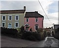
2
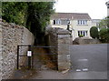
Path to Maines Batch
A short footpath from the High Street.
Image: © Neil Owen
Taken: 23 Aug 2018
0.02 miles
3
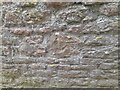
Ordnance Survey Cut Mark
This OS cut mark can be found on the wall NE side of the road. It marks a point 35.991m above mean sea level.
Image: © Adrian Dust
Taken: 25 Jul 2022
0.05 miles
4
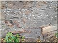
Ordnance Survey Cut Mark
This OS cut mark can be found on a building east side of the road. It marks a point 23.362m above mean sea level.
Image: © Adrian Dust
Taken: 25 Jul 2022
0.07 miles
5
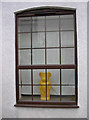
A bear at the window
An interested onlooker in the High Street.
Image: © Neil Owen
Taken: 23 Aug 2018
0.08 miles
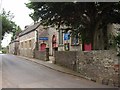
7
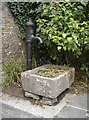
Wrington's water
An old pump on the High Street has served its time to the village over the years and is now a reminder of the past. The trough, which used to hold the water, now holds flowers - or at least it would do if there had not been such a dry summer!
Maker: Lee Howl, and renovated in 1985, according to a plaque.
Image: © Neil Owen
Taken: 23 Aug 2018
0.09 miles
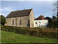
8
Wrington United Reformed Church
Formerly a Congregational Chapel.
Image: © Neil Owen
Taken: 23 Aug 2018
0.09 miles
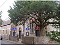
9
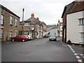
Wrington High Street looking north
For further information see the village website http://www.wringtonsomerset.org.uk/
Image: © FollowMeChaps
Taken: 2 Jan 2006
0.09 miles
10
Roper's Lane, Wrington
Seen from the corner of Chapel Hill, with Wrington Chapel (built, I think, in 1815) on the right; this building is also shown from across a field in Image
Image: © Derek Harper
Taken: 16 May 2011
0.09 miles