IMAGES TAKEN NEAR TO
Wrington Hill, BRISTOL, BS40 5PN
Introduction
This page details the photographs taken nearby to Wrington Hill, BS40 5PN by members of the Geograph project.
The Geograph project started in 2005 with the aim of publishing, organising and preserving representative images for every square kilometre of Great Britain, Ireland and the Isle of Man.

There are currently over 7.5m images from over14,400 individuals and you can help contribute to the project by visiting https://www.geograph.org.uk
Image Map (Loading...)


Getting Data...Please wait
Leaflet Map data © OpenStreetMap
Images are licensed for reuse under creativecommons.org/licenses/by-sa/2.0
Notes
- Clicking on the map will re-center to the selected point.
- The higher the marker number, the further away the image location is from the centre of the postcode.
Image Listing (4 Images Found)
Images are licensed for reuse under creativecommons.org/licenses/by-sa/2.0
Image
Details
Distance
1
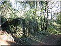
Catching on Bracken Hill
Difficult to spot under the vegetation, but the large structure is a water catch tank.
Image: © Neil Owen
Taken: 4 Nov 2021
0.10 miles
2
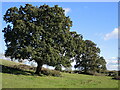
Oaks on the slope
Some fine examples in amongst the cattle pasture.
Image: © Neil Owen
Taken: 4 Nov 2021
0.12 miles
3
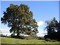
An oak between the woods
A few fields of pasture stand between Corporation Woods and Simshill Wood, with a few solitary specimens dotted here and there.
Image: © Neil Owen
Taken: 4 Nov 2021
0.13 miles
4
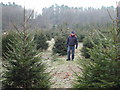
Replanted areas in the north of this grid square
Parts of the northern end of this grid square have been cleared for replanting of firs. This area also provides roosts for pheasant which are bred locally.
Image: © FollowMeChaps
Taken: 29 Dec 2005
0.21 miles