IMAGES TAKEN NEAR TO
Havyatt Road Trading Estate, Havyatt Road, BRISTOL, BS40 5PA
Introduction
This page details the photographs taken nearby to Havyatt Road Trading Estate, Havyatt Road, BS40 5PA by members of the Geograph project.
The Geograph project started in 2005 with the aim of publishing, organising and preserving representative images for every square kilometre of Great Britain, Ireland and the Isle of Man.

There are currently over 7.5m images from over14,400 individuals and you can help contribute to the project by visiting https://www.geograph.org.uk
Image Map
Images are licensed for reuse under creativecommons.org/licenses/by-sa/2.0
Notes
- Clicking on the map will re-center to the selected point.
- The higher the marker number, the further away the image location is from the centre of the postcode.
Image Listing (28 Images Found)
Images are licensed for reuse under creativecommons.org/licenses/by-sa/2.0
Image
Details
Distance
1
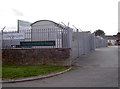
Wrington business park
Built over the old railway line and boasting some modern photovoltaic panelling in the back yard.
Image: © Neil Owen
Taken: 29 Aug 2018
0.05 miles
2
Warm Glass
An intriguing sign on Havyat Road.
Image: © Neil Owen
Taken: 29 Aug 2018
0.09 miles
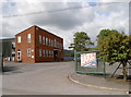
4
Burnett Industrial Estate
This is the Wrington site and not to be confused with the Burnett near Keynsham, some 21km (13 Miles) away.
Image: © Neil Owen
Taken: 29 Aug 2018
0.09 miles
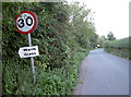
5
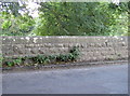
How Somerset marks the bridges
Wrington Bridge, with a typical Somerset County Council feature of the inscribed stonework. Many such small bridges are thus.
Image: © Neil Owen
Taken: 29 Aug 2018
0.15 miles
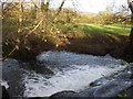
6
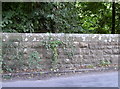
The old County Bridge
Wrington Bridge, spanning the Yeo, and rebuilt in 1910.
Image: © Neil Owen
Taken: 29 Aug 2018
0.15 miles
8
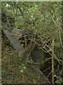
Leftover from the times of steam
This little but sturdy bridge used to carry the old Wrington Vale Light Railway until it closed in 1963. Pedestrians would have walked underneath it.
Image: © Neil Owen
Taken: 29 Aug 2018
0.16 miles
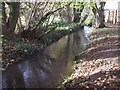
9
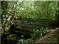
Bridge near Beam Mill
The footpath through what was the old Beam puff Mill is somewhat lacking in specific markers, but this bridge over the stream is a clue to being on the right track.
Image: © Neil Owen
Taken: 29 Aug 2018
0.17 miles