IMAGES TAKEN NEAR TO
Old Station Close, BRISTOL, BS40 5LY
Introduction
This page details the photographs taken nearby to Old Station Close, BS40 5LY by members of the Geograph project.
The Geograph project started in 2005 with the aim of publishing, organising and preserving representative images for every square kilometre of Great Britain, Ireland and the Isle of Man.

There are currently over 7.5m images from over14,400 individuals and you can help contribute to the project by visiting https://www.geograph.org.uk
Image Map (Loading...)


Getting Data...Please wait
Leaflet Map data © OpenStreetMap
Images are licensed for reuse under creativecommons.org/licenses/by-sa/2.0
Notes
- Clicking on the map will re-center to the selected point.
- The higher the marker number, the further away the image location is from the centre of the postcode.
Image Listing (112 Images Found)
Images are licensed for reuse under creativecommons.org/licenses/by-sa/2.0
Image
Details
Distance
1
Nothing of the station
This view in The Glebe shows little but modern houses. However, this site was the old Wrington railway station, which operated from 1901 to 1963. The line was primarily intended to supply communications for the construction of Blagdon reservoir, but also carried passengers for a few years. The station itself was not a particularly extensive one.
Image: © Neil Owen
Taken: 29 Aug 2018
0.04 miles
2
An unexpected backslash
Not every day you see a backslash on a signpost.
Image: © Neil Owen
Taken: 29 Aug 2018
0.06 miles
3
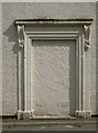
Blanked off on Station Road
This wall has a fine surround for a doorway, but opening directly onto the road is probably why there is no door here.
Image: © Neil Owen
Taken: 29 Aug 2018
0.07 miles
4
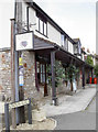
Railway Wharf
A new rank of shops on Station Road, offering such varied joys as a luxurious pampering or tickets for F1 races.
Image: © Neil Owen
Taken: 29 Aug 2018
0.08 miles
5
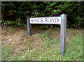
A very small warning
Kings Road is a short enough stretch of road but the No Through Road sign is going to be difficult to spot to motorists.
Image: © Neil Owen
Taken: 29 Aug 2018
0.08 miles
6
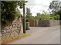
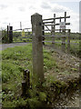
Benchmark on Station Road
An innocuous enough location for a humble cut mark - on a wall at Butt's Batch south of Wrington. See Image] for a closer.
Image: © Neil Owen
Taken: 29 Aug 2018
0.09 miles
7
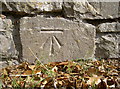
Benchmark on the wall
A rustic stone wall bears a well-defined benchmark. See https://www.bench-marks.org.uk/bm99207 for the entry in the Benchmark Database and Image] for a wider view.
Image: © Neil Owen
Taken: 29 Aug 2018
0.09 miles
8
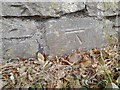
Ordnance Survey Cut Mark
This OS cut mark can be found on the wall east side of the road. It marks a point 19.517m above mean sea level.
Image: © Adrian Dust
Taken: 25 Jul 2022
0.09 miles
9
A clue to the steamy past
A couple of pieces of old railway track iron are remnants of the old Wrington Vale Light Railway.
Image: © Neil Owen
Taken: 29 Aug 2018
0.12 miles