IMAGES TAKEN NEAR TO
The Triangle, BRISTOL, BS40 5LE
Introduction
This page details the photographs taken nearby to The Triangle, BS40 5LE by members of the Geograph project.
The Geograph project started in 2005 with the aim of publishing, organising and preserving representative images for every square kilometre of Great Britain, Ireland and the Isle of Man.

There are currently over 7.5m images from over14,400 individuals and you can help contribute to the project by visiting https://www.geograph.org.uk
Image Map
Images are licensed for reuse under creativecommons.org/licenses/by-sa/2.0
Notes
- Clicking on the map will re-center to the selected point.
- The higher the marker number, the further away the image location is from the centre of the postcode.
Image Listing (128 Images Found)
Images are licensed for reuse under creativecommons.org/licenses/by-sa/2.0
Image
Details
Distance
1
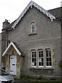
Wrington Church office
Originally a reading room for the local men. See Image] for a look at the porch inscription.
Image: © Neil Owen
Taken: 23 Aug 2018
0.01 miles
2
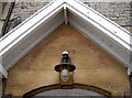
The old Reading Rooms
Now the church office, this old building was an important facility in the village. For many villagers at the time, education was out of reach until such an institution made learning available. It was built in 1866 by Mrs Marianne Young, who lived in Maine's Batch. She specified that it was to be "with or without a lending library, with or without innocent games and amusements, but wholly free from gambling of every kind". When she died in 1897, aged 86, the deeds allowed the room to be maintained by local clergy and working men.
During the Great War, the building was used for religious services for Belgian refugees; later, it also offered cookery classes and the like.
See Image] for a wider view.
Image: © Neil Owen
Taken: 23 Aug 2018
0.01 miles
3
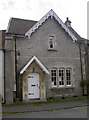
The Old Reading Room
Now church offices and a community facility.
Image: © Neil Owen
Taken: 29 Aug 2018
0.01 miles
4
Hanging out the window
A slightly odd sight above a house window. However, a closer look at the building reveals it is The Old Bakehouse, so it seems likely this was a more industrial site than the present.
Image: © Neil Owen
Taken: 29 Aug 2018
0.01 miles
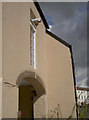
5
Dial House
Part of the architectural heritage along Broad Street in Wrington, this has an archway and a sundial - see Image] for the latter.
Image: © Neil Owen
Taken: 29 Aug 2018
0.01 miles
6
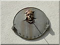
Stylish sundial
High on the wall of a house in Broad Street - see Image] for a wider view.
Image: © Neil Owen
Taken: 29 Aug 2018
0.01 miles
7
An old sign at the top of Station Road
Wrington's centre has a few pre-Worboys road signs.
Image: © Neil Owen
Taken: 29 Aug 2018
0.02 miles
8
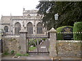
Gate to All Saints
These gates were built by local man Cliff Croker, and were restored by Lois Trott in 1977.
Image: © Neil Owen
Taken: 23 Aug 2018
0.03 miles
9
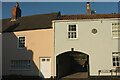
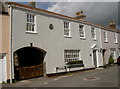
Houses in Wrington
With a carriage entrance, at the junction of Broad Street and Station Road. Don't miss Neil's photo of the unusual sundial seen at upper right Image
Image: © Derek Harper
Taken: 24 Jan 2023
0.03 miles
10
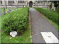
Please keep on the walks
A nicer way of saying 'Keep off the grass!'
Image: © Neil Owen
Taken: 23 Aug 2018
0.03 miles