IMAGES TAKEN NEAR TO
Main Street, BRISTOL, BS39 6UL
Introduction
This page details the photographs taken nearby to Main Street, BS39 6UL by members of the Geograph project.
The Geograph project started in 2005 with the aim of publishing, organising and preserving representative images for every square kilometre of Great Britain, Ireland and the Isle of Man.

There are currently over 7.5m images from over14,400 individuals and you can help contribute to the project by visiting https://www.geograph.org.uk
Image Map (Loading...)


Getting Data...Please wait
Leaflet Map data © OpenStreetMap
Images are licensed for reuse under creativecommons.org/licenses/by-sa/2.0
Notes
- Clicking on the map will re-center to the selected point.
- The higher the marker number, the further away the image location is from the centre of the postcode.
Image Listing (29 Images Found)
Images are licensed for reuse under creativecommons.org/licenses/by-sa/2.0
Image
Details
Distance
1
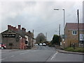
2009 : A362 looking west at Paulton Road
On the edge of Farrington Gurney.
The establishment on the left appears to be a curry house called the Spice Something.
Image: © Maurice Pullin
Taken: 16 Nov 2009
0.01 miles
2
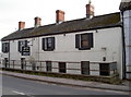
Spice Dunes
An Indian restaurant that used to the Miner's Arms pub. See Image] for a reminder of the past.
Image: © Neil Owen
Taken: 30 Mar 2016
0.01 miles
3
Stand down of the Arms
This old pub was the Miner's Arms - appropriate for the contribution of collieries in this part of Somerset. It closed some time ago and is now Spice Dunes, an Indian restaurant with a good local reputation.
Image: © Neil Owen
Taken: 30 Mar 2016
0.01 miles
4
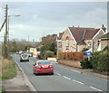
2009 : A362 entering Farrington Gurney
Near the end of Paulton Road.
Image: © Maurice Pullin
Taken: 16 Nov 2009
0.02 miles
5
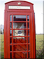
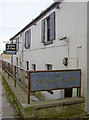
Village notice board
Of course, only a fool would think it was a telephone box - it may have been one, once. One notice is that of Farrington Gurney Parish Council, who presumably have the rights to it now. The council do not offer phone services.
Image: © Neil Owen
Taken: 30 Mar 2016
0.05 miles
6
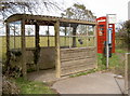
Concrete and asbestos
The bus stop here on the A362 in Farrington Gurney is an odd one: it is made of modular concrete sections and has a roof of curved asbestos sheets. They don't make them like that anymore. See Image] for the redundant telephone box in the background.
Image: © Neil Owen
Taken: 30 Mar 2016
0.05 miles
7
Old Direction Sign - Signpost by the A362, Farrington Gurney Parish
Lost finial - 2 arms; Somerset SCC pyramid by the A362, in parish of Farrington Gurney (Bath And North East Somerset District), in hedge at back of wide grass verge, at junction with Paulton Road.
Surveyed
Milestone Society National ID: SO_ST6355A.
Image: © Milestone Society
Taken: Unknown
0.06 miles
8
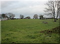
2009 : Line of the old railway from Bristol
This is the line of the old GWR single track railway from Bristol to Paulton via Whitchurch, Pensford and Clutton. The field shown here is a filled in cutting.
Image: © Maurice Pullin
Taken: 16 Nov 2009
0.08 miles
9
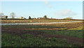
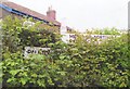
Arable field near Farrington Gurney
Looking left from Image The houses are on Ruett Lane.
Image: © Derek Harper
Taken: 9 Dec 2019
0.13 miles
10
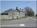
Farrington's Farm, Farrington Gurney
Image: © Roger Cornfoot
Taken: 23 Apr 2010
0.16 miles