IMAGES TAKEN NEAR TO
Church Lane, BRISTOL, BS39 5XA
Introduction
This page details the photographs taken nearby to Church Lane, BS39 5XA by members of the Geograph project.
The Geograph project started in 2005 with the aim of publishing, organising and preserving representative images for every square kilometre of Great Britain, Ireland and the Isle of Man.

There are currently over 7.5m images from over14,400 individuals and you can help contribute to the project by visiting https://www.geograph.org.uk
Image Map
Images are licensed for reuse under creativecommons.org/licenses/by-sa/2.0
Notes
- Clicking on the map will re-center to the selected point.
- The higher the marker number, the further away the image location is from the centre of the postcode.
Image Listing (52 Images Found)
Images are licensed for reuse under creativecommons.org/licenses/by-sa/2.0
Image
Details
Distance
2
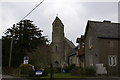
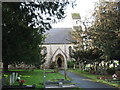
Church & Primary School in Bishop Sutton
School on the right.
Could not find the name of the church, however a passerby told us they thought it was Holy Trinity
Image: © Adrian and Janet Quantock
Taken: 18 Mar 2006
0.06 miles
5
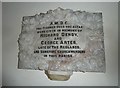
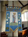
Holy Trinity, Bishop Sutton: commemoration
Image: © Basher Eyre
Taken: 14 Sep 2012
0.06 miles
6
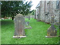
Holy Trinity, Bishop Sutton: churchyard (b)
Image: © Basher Eyre
Taken: 14 Sep 2012
0.06 miles
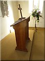
7
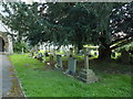
Holy Trinity, Bishop Sutton: churchyard (a)
Image: © Basher Eyre
Taken: 14 Sep 2012
0.06 miles
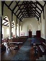
8
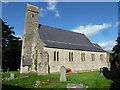
Holy Trinity, Bishop Sutton: September 2012
Image: © Basher Eyre
Taken: 14 Sep 2012
0.06 miles
10
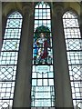
Holy Trinity, Bishop Sutton: stained glass window (II)
Image: © Basher Eyre
Taken: 14 Sep 2012
0.06 miles