IMAGES TAKEN NEAR TO
Stowey Road, BRISTOL, BS39 5TG
Introduction
This page details the photographs taken nearby to Stowey Road, BS39 5TG by members of the Geograph project.
The Geograph project started in 2005 with the aim of publishing, organising and preserving representative images for every square kilometre of Great Britain, Ireland and the Isle of Man.

There are currently over 7.5m images from over14,400 individuals and you can help contribute to the project by visiting https://www.geograph.org.uk
Image Map
Images are licensed for reuse under creativecommons.org/licenses/by-sa/2.0
Notes
- Clicking on the map will re-center to the selected point.
- The higher the marker number, the further away the image location is from the centre of the postcode.
Image Listing (12 Images Found)
Images are licensed for reuse under creativecommons.org/licenses/by-sa/2.0
Image
Details
Distance
1

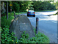
2010 : Cholwell House Nursing Home
Seen from the A37.
Image: © Maurice Pullin
Taken: 22 Jun 2010
0.15 miles
4
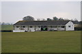
Temple Cloud Cricket Pavilion
Image: © Adrian and Janet Quantock
Taken: 18 Mar 2006
0.19 miles
5
2010 : Clutton M. M.
From this one may infer that Clutton had a Millennium Project which involved placing large stones by the roadside with a plate attached to them bearing the inscription "CLUTTON M.M."
Its purpose is unclear, have found nothing on the web.
Image: © Maurice Pullin
Taken: 22 Jun 2010
0.19 miles
6
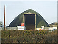
Stocked with road salt
The domed council depot in Clutton is already being depleted.
Image: © Neil Owen
Taken: 15 Jan 2021
0.19 miles
7
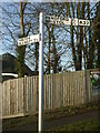
How un-Somerset
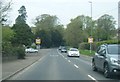
This signpost is not of the traditional Somerset style - a stout post in grey with the pyramidical finial. At least the arms are in keeping. Has this one been damaged and replaced with this anonynous post?
Image: © Neil Owen
Taken: 15 Jan 2021
0.20 miles
8
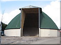
Highways Agency salt store Clutton
These curious tall dome shaped buildings can be seen dotted around the country, built out of wood (one may speculate they are less prone to corrosion) and operated by the Highways Agency, they are often sited near steep hills on main routes.
Image: © Dr Duncan Pepper
Taken: 7 Mar 2008
0.20 miles
9

2010 : Cholwell Farms Ltd., the entrance
Authorised access only.
From a search of the internet it would appear they do everything a farmer could want from solar energy to dating.
Image: © Maurice Pullin
Taken: 22 Jun 2010
0.20 miles