IMAGES TAKEN NEAR TO
Upper Bristol Road, BRISTOL, BS39 5TE
Introduction
This page details the photographs taken nearby to Upper Bristol Road, BS39 5TE by members of the Geograph project.
The Geograph project started in 2005 with the aim of publishing, organising and preserving representative images for every square kilometre of Great Britain, Ireland and the Isle of Man.

There are currently over 7.5m images from over14,400 individuals and you can help contribute to the project by visiting https://www.geograph.org.uk
Image Map
Images are licensed for reuse under creativecommons.org/licenses/by-sa/2.0
Notes
- Clicking on the map will re-center to the selected point.
- The higher the marker number, the further away the image location is from the centre of the postcode.
Image Listing (44 Images Found)
Images are licensed for reuse under creativecommons.org/licenses/by-sa/2.0
Image
Details
Distance
1
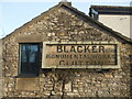
Blacker's monument
The sign gives the firm's foundation as early eighteenth century and appear to still be in business. The sign is beside a property named the Old Marble Works.
Image: © Neil Owen
Taken: 15 Jan 2021
0.04 miles
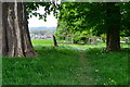
2
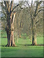
To Church Farm and the Church of St Augustine
A lovely tree-lined avenue leads from the main road down to the old church. How many worshippers would have taken this path to services over the years?
Image: © Neil Owen
Taken: 15 Jan 2021
0.05 miles
3
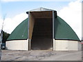
Highways Agency salt store Clutton
These curious tall dome shaped buildings can be seen dotted around the country, built out of wood (one may speculate they are less prone to corrosion) and operated by the Highways Agency, they are often sited near steep hills on main routes.
Image: © Dr Duncan Pepper
Taken: 7 Mar 2008
0.05 miles
4
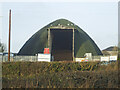
Stocked with road salt
The domed council depot in Clutton is already being depleted.
Image: © Neil Owen
Taken: 15 Jan 2021
0.06 miles
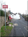
5
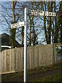
How un-Somerset
This signpost is not of the traditional Somerset style - a stout post in grey with the pyramidical finial. At least the arms are in keeping. Has this one been damaged and replaced with this anonynous post?
Image: © Neil Owen
Taken: 15 Jan 2021
0.06 miles
9
Beware the locals?
The sign refers to motorists using the narrow road to the school, not to the pedestrians themselves.
Image: © Neil Owen
Taken: 15 Jan 2021
0.15 miles
10
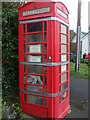
Cold calls for Covid
This community asset (an old telephone box) is now closed. Used as a library/toy store, it has now been sealed by tape to help stop infection.
Image: © Neil Owen
Taken: 15 Jan 2021
0.16 miles