IMAGES TAKEN NEAR TO
Marsh Lane, BRISTOL, BS39 5ST
Introduction
This page details the photographs taken nearby to Marsh Lane, BS39 5ST by members of the Geograph project.
The Geograph project started in 2005 with the aim of publishing, organising and preserving representative images for every square kilometre of Great Britain, Ireland and the Isle of Man.

There are currently over 7.5m images from over14,400 individuals and you can help contribute to the project by visiting https://www.geograph.org.uk
Image Map
Images are licensed for reuse under creativecommons.org/licenses/by-sa/2.0
Notes
- Clicking on the map will re-center to the selected point.
- The higher the marker number, the further away the image location is from the centre of the postcode.
Image Listing (6 Images Found)
Images are licensed for reuse under creativecommons.org/licenses/by-sa/2.0
Image
Details
Distance
1
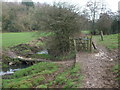
A crossing near Cloud Hill Farm
The Long Lands path is part of the Limestone Link. Here a small bridge affords a chance to go to Greyfield Wood. Either way is rather muddy, though.
Image: © Neil Owen
Taken: 15 Jan 2021
0.06 miles
2
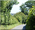
2010 : Marsh Lane between Hallatrow and Clutton
Heading north west toward Clutton.
A hazel hedge is seen on the right. Although without thorns hazel makes a good hedge, stockproof if planted close enough but do not expect many nuts.
Image: © Maurice Pullin
Taken: 22 Jun 2010
0.06 miles
4
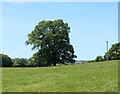
2010 : Oak tree in a field off Marsh Lane
The dismantled railway line between Bristol and Paulton is behind the hedgerow to the left.
The houses in the distance are in Clutton.
Image: © Maurice Pullin
Taken: 22 Jun 2010
0.12 miles
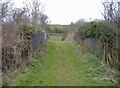
5
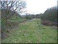
Railway trackbed, Cloud Hill
The abandoned, former GWR line from Bristol to Frome.
Image: © Roger Cornfoot
Taken: 12 Mar 2007
0.13 miles
6
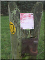
The path to where?
Some contrary directions on a post in the Long Lands section of the Limestone Link. The path runs alongside the stream for the most part, nevertheless.
Image: © Neil Owen
Taken: 15 Jan 2021
0.24 miles