IMAGES TAKEN NEAR TO
Lower Bristol Road, BRISTOL, BS39 5QR
Introduction
This page details the photographs taken nearby to Lower Bristol Road, BS39 5QR by members of the Geograph project.
The Geograph project started in 2005 with the aim of publishing, organising and preserving representative images for every square kilometre of Great Britain, Ireland and the Isle of Man.

There are currently over 7.5m images from over14,400 individuals and you can help contribute to the project by visiting https://www.geograph.org.uk
Image Map
Images are licensed for reuse under creativecommons.org/licenses/by-sa/2.0
Notes
- Clicking on the map will re-center to the selected point.
- The higher the marker number, the further away the image location is from the centre of the postcode.
Image Listing (12 Images Found)
Images are licensed for reuse under creativecommons.org/licenses/by-sa/2.0
Image
Details
Distance
1
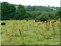
Cattle in a field near Breach
I'm no expert but these look like they have Hereford genes to judge from their white faces.
Image: © Brian Robert Marshall
Taken: 1 Jul 2007
0.11 miles
2
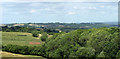
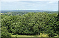
2010 : North east from Lower Bristol Road
100 yards or so north of Breach. Fry's Bottom is in the foreground.
Compton Dando is hidden in the valley mid distance, unseen on this image.
Lansdown, north of Bath, lies faint on the horizon to the right.
Image: © Maurice Pullin
Taken: 5 Jul 2010
0.11 miles
3
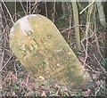
Old Milestone by the A37, Red Hill, Chelwood Parish
Carved stone post by the A37, in parish of CHELWOOD (BATH AND NORTH EAST SOMERSET District), Red Hill, North of Clutton, on grass verge in front of hedge, on East side of road. Bristol stone - Arabic, erected by the Bristol turnpike trust in the 18th century.
Inscription reads:-
8
Miles
To
BRISTOL
Iron Bridge
Carved benchmark lower front.
Milestone Society National ID: SO_BRCT08.
Image: © JR Dowding
Taken: 25 Jan 2003
0.13 miles
5
2010 : East from Lower Bristol Road nr. Breach
The line of the dismantled North Somerset Railway is among the trees at the bottom of the frame.
Image: © Maurice Pullin
Taken: 5 Jul 2010
0.14 miles
6
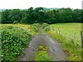
Track to the old North Somerset Railway, near Breach
The trackbed of the old railway is just in front of the tree line at the end of the track. There is a project afoot to re-open the line from Radstock to Frome south of here. It seems unlikely that the project will extend this far north. More here http://www.northsomersetrailway.com/
Image: © Brian Robert Marshall
Taken: 1 Jul 2007
0.14 miles
7
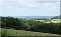
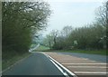
2010 : East from Lower Bristol Road
Between Breach and North End.
The line of the former North Somerset Railway is on the far side of this field, the woods beyond it hide a long gone coal mine.
Image: © Maurice Pullin
Taken: 5 Jul 2010
0.16 miles
8
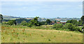
2010 : North from Lower Bristol Road
North of Breach.
The cow pasture in the foreground seems to be in need of attention, a good collection of thistles.
We get a glimpse of Lower Bristol Road on the right hand edge and a brief look at the A37 which it joins a few yards on.
Park Farm is prominent, and we can partly peruse Pensford further over.
Image: © Maurice Pullin
Taken: 5 Jul 2010
0.20 miles
9
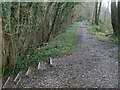
Dropping down to cross the old track
The North Somerset railway used to run through Fry's Bottom Wood. Now ripped up the track can be crossed by a footpath that has some handy steps to negotiate the embankment.
Image: © Neil Owen
Taken: 15 Jan 2021
0.21 miles
10
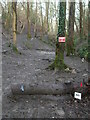
This is the end
Part of the old railway line now appears to be an outdoor activity area. Whoever uses it must like mud.
Image: © Neil Owen
Taken: 15 Jan 2021
0.22 miles