IMAGES TAKEN NEAR TO
Greyfield View, BRISTOL, BS39 5DL
Introduction
This page details the photographs taken nearby to Greyfield View, BS39 5DL by members of the Geograph project.
The Geograph project started in 2005 with the aim of publishing, organising and preserving representative images for every square kilometre of Great Britain, Ireland and the Isle of Man.

There are currently over 7.5m images from over14,400 individuals and you can help contribute to the project by visiting https://www.geograph.org.uk
Image Map (Loading...)


Getting Data...Please wait
Leaflet Map data © OpenStreetMap
Images are licensed for reuse under creativecommons.org/licenses/by-sa/2.0
Notes
- Clicking on the map will re-center to the selected point.
- The higher the marker number, the further away the image location is from the centre of the postcode.
Image Listing (9 Images Found)
Images are licensed for reuse under creativecommons.org/licenses/by-sa/2.0
Image
Details
Distance
1
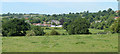
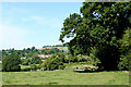
2010 : Temple Cloud from Marsh Lane
Looking across the grid square.
Cameley is in the distance.
Image: © Maurice Pullin
Taken: 22 Jun 2010
0.05 miles
2
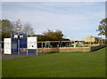
Temple Cloud recreation ground
A range of active opportunities. See https://www.geograph.org.uk/photo/5953663 for a look at the target boards.
Image: © Neil Owen
Taken: 23 Oct 2018
0.15 miles
3
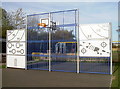
A ball of any kind
Take your pick of targets and sports!
Image: © Neil Owen
Taken: 23 Oct 2018
0.15 miles
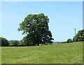
4
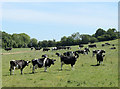
Cattle in a field near Temple Cloud
"What's happening! What's happening?"
"It's all right Daisy, don't worry, that fool geographer must have pressed the 'browse' button."
Image: © Maurice Pullin
Taken: 22 Jun 2010
0.15 miles
5
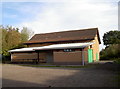
Temple Cloud village hall
Part of the parish of Cameley, this modern hall offers sprung flooring and a curtained stage.
Image: © Neil Owen
Taken: 23 Oct 2018
0.17 miles
6
2010 : North west from Marsh Lane
If you look carefully you can almost see Clutton. Most of it is behind the oak tree but there are a few houses spilling out.
Image: © Maurice Pullin
Taken: 22 Jun 2010
0.21 miles
7
2010 : Oak tree in a field off Marsh Lane
The dismantled railway line between Bristol and Paulton is behind the hedgerow to the left.
The houses in the distance are in Clutton.
Image: © Maurice Pullin
Taken: 22 Jun 2010
0.23 miles
8
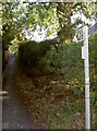
Footpath off Temple Inn Lane
A new path created when the modern housing estate was built, replacing one that ran nearby across a plain field.
Image: © Neil Owen
Taken: 23 Oct 2018
0.24 miles
9

Sold on Temple Inn Lane
The latest housing development in the expanding village of Temple Cloud.
Image: © Neil Owen
Taken: 23 Oct 2018
0.25 miles