IMAGES TAKEN NEAR TO
Marsh Lane, BRISTOL, BS39 5AZ
Introduction
This page details the photographs taken nearby to Marsh Lane, BS39 5AZ by members of the Geograph project.
The Geograph project started in 2005 with the aim of publishing, organising and preserving representative images for every square kilometre of Great Britain, Ireland and the Isle of Man.

There are currently over 7.5m images from over14,400 individuals and you can help contribute to the project by visiting https://www.geograph.org.uk
Image Map (Loading...)


Getting Data...Please wait
Leaflet Map data © OpenStreetMap
Images are licensed for reuse under creativecommons.org/licenses/by-sa/2.0
Notes
- Clicking on the map will re-center to the selected point.
- The higher the marker number, the further away the image location is from the centre of the postcode.
Image Listing (8 Images Found)
Images are licensed for reuse under creativecommons.org/licenses/by-sa/2.0
Image
Details
Distance
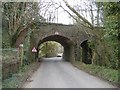
1
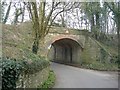
Railway bridge, Cloud Hill
The road from Temple Cloud to Hallatrow passes under the abandoned Bristol to Frome line.
Image: © Roger Cornfoot
Taken: 12 Mar 2007
0.03 miles
2
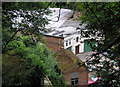
The Shadow Factory from above
This is another picture of the old Lancaster bomber factory, hidden in a quarry see http://www.geograph.org.uk/photo/1405928
Image: © Rick Crowley
Taken: 18 Jul 2008
0.12 miles
3
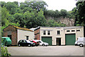
The Shadow Factory
This is the entrance to Cloud Hill Enterprises, now a business Park. Unit 25 used to be Arc Microfilm which became Arc Document Management. Locally it is still known as the Shadow Factory. It was built early in World War Two for the Parnall Aircraft Company after it’s Yate factory was bombed. As many as 400 people worked here building among other things wings and tail planes for Lancaster bombers. Originally there was a railway line into it passing from behind where the picture was taken, and going into the right hand entrance. It had a much larger entrance with large sliding doors, which have only recently gone. During the war the roof was painted to look like water so the Germans would not find it.
The quarry was made originally for material for the Pensford Railway Viaduct. Another picture see http://www.geograph.org.uk/photo/1406074
Image: © Rick Crowley
Taken: 18 Jul 2008
0.12 miles
4
Mill house, Hallatrow
Sandwiched between the two abandoned railway lines that once formed Hallatrow Junction.
Image: © Roger Cornfoot
Taken: 12 Mar 2007
0.13 miles
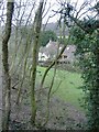
5
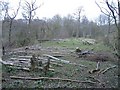
Abandoned railway trackbed
Some tree felling has been undertaken at this point, on the former Bristol to Frome line.
Image: © Roger Cornfoot
Taken: 12 Mar 2007
0.14 miles
6
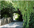
2010 : Railway bridge on the minor road to Hallatrow
Image] shows the bridge from the opposite direction, comments there apply.
After leaving Hallatrow Station the line went along the River Cam Valley passing through Radford, Dunkerton, Combe Hay and Midford, joining the GWR line north of Limpley Stoke.
Image: © Maurice Pullin
Taken: 22 Jun 2010
0.15 miles
7
Railway bridge, Hallatrow
Close to the abandoned Hallatrow junction station, once located beyond the left of this view.
Image: © Roger Cornfoot
Taken: 12 Mar 2007
0.15 miles
8
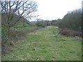
Railway trackbed, Cloud Hill
The abandoned, former GWR line from Bristol to Frome.
Image: © Roger Cornfoot
Taken: 12 Mar 2007
0.22 miles