IMAGES TAKEN NEAR TO
Cameley Close, BRISTOL, BS39 5AD
Introduction
This page details the photographs taken nearby to Cameley Close, BS39 5AD by members of the Geograph project.
The Geograph project started in 2005 with the aim of publishing, organising and preserving representative images for every square kilometre of Great Britain, Ireland and the Isle of Man.

There are currently over 7.5m images from over14,400 individuals and you can help contribute to the project by visiting https://www.geograph.org.uk
Image Map (Loading...)


Getting Data...Please wait
Leaflet Map data © OpenStreetMap
Images are licensed for reuse under creativecommons.org/licenses/by-sa/2.0
Notes
- Clicking on the map will re-center to the selected point.
- The higher the marker number, the further away the image location is from the centre of the postcode.
Image Listing (28 Images Found)
Images are licensed for reuse under creativecommons.org/licenses/by-sa/2.0
Image
Details
Distance
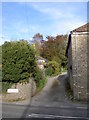
1
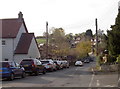
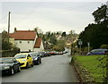
Cameley Road
Leading from the centre of Temple Cloud and off to the old village.
Image: © Neil Owen
Taken: 23 Oct 2018
0.03 miles
2
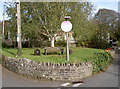
Temple Cloud's old exchange
This little triangle of greenery sits at the junction of Cameley Road and the busy A37 Wells Road. It is not quite the oasis it may seem, but the grass has covered over what was the site of the village's old automatic telephone exchange.
Image: © Neil Owen
Taken: 23 Oct 2018
0.05 miles
3
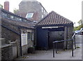
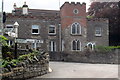
The Doctor's barn is open
Temple Cloud's surgery has a rather unusual entrance!
Image: © Neil Owen
Taken: 23 Oct 2018
0.05 miles
5
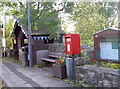
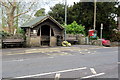
All manner of communications
The small patch of grass at the junction of the A37 and Cameley Road is a place to find many forms of communication. Even the wooden bus shelter has a sense of celebration.
Image: © Neil Owen
Taken: 23 Oct 2018
0.05 miles
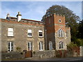
6
Signpost and crenellated house on the A37
Image: © Philip Jeffrey
Taken: 8 May 2013
0.05 miles
7
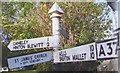
Direction Sign - Signpost on the A37 in Temple Cloud
Pyramid finial - 3 arms; Somerset SCC pyramid by the A37, in parish of Cameley (Bath And North East Somerset District), in Temple Cloud on the northwest side of the Y junction of the A37 Bristol Road and Camely Road.
surveyed
Milestone Society National ID: SO_ST6257
Image: © Milestone Society
Taken: Unknown
0.05 miles
8
2008 : Cameley Road, Temple Cloud
Taken from the junction with the A37.
Image: © Maurice Pullin
Taken: 19 Dec 2008
0.06 miles
9
The Refuge
A particularly interesting old building in Temple Cloud: it is believed to have sixteenth century foundations, starting as the Bell Inn, and having several changes of owner and styles since then!
Image: © Neil Owen
Taken: 23 Oct 2018
0.06 miles
10
Gillet's Hill Lane
A small lane of the main A37 and a fairly new part of the village.
Image: © Neil Owen
Taken: 23 Oct 2018
0.07 miles