1
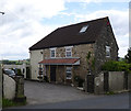
Tollhouse by the A37, Chelwood
Chelwood Tollhouse by the A37, in parish of Publow (Bath and North East Somerset District), Tyreece, Whitley Batts Road, BS39 4NQ.
Bath & North East Somerset HER.
HER number: 62805 https://www.heritagegateway.org.uk/Gateway/Results_Single.aspx?uid=62805&resourceID=1036
Surveyed
Milestone Society National ID: AV.PUB
Image: © Alan Rosevear
Taken: 24 Jun 2013
0.00 miles
2
A37 northbound
Image: © Alex McGregor
Taken: 20 Jun 2012
0.13 miles
3
2009 : A368, near the Chelwood Roundabout
A lone motorcyclist approaches the roundabout though all you can see of it from here is the lamp posts.
Coming in on the road from Weston super Mare and Bishop Sutton.
The A368 crosses the A37 here.
Image: © Maurice Pullin
Taken: 15 Mar 2009
0.14 miles
4
2009 : North from the A368
Near Chelwood Roundabout looking over a field of maize stubble.
Salter's Brook runs unseen in the valley and Stanton Wick, also unseen is on the other side and to the left a bit.
Image: © Maurice Pullin
Taken: 15 Mar 2009
0.16 miles
5
A37 northbound
Image: © Alex McGregor
Taken: 20 Jun 2012
0.17 miles
6
An embryonic woodland
These young trees are becoming a firm feature; a path is neatly defined.
Image: © Neil Owen
Taken: 26 Mar 2021
0.21 miles
7
Meadows north of the A368 near Stanton Wick
Image: © David Gearing
Taken: 28 Sep 2011
0.22 miles
8
Unzipping the collar
As the trunks expand and the trees grow, these protective plastic sheaths are being unzipped. A slow arboreal version of the Incredible Hulk.
Image: © Neil Owen
Taken: 26 Mar 2021
0.22 miles
9
2009 : A368 west of Chelwood
If we take the byroad at the top of the hill it takes the pretty route to Clutton, but enough of these fripperies, the A368 deserves to be followed further to the Chelwood roundabout then on to Bishop Sutton and West Harptree.
Image: © Maurice Pullin
Taken: 15 Mar 2009
0.23 miles
10
2009 : A368 close to Stanton Wick
Facing west and going on to Bishop Sutton. The road here drops into the valley of Salter's Brook.
Image: © Maurice Pullin
Taken: 15 Mar 2009
0.23 miles


